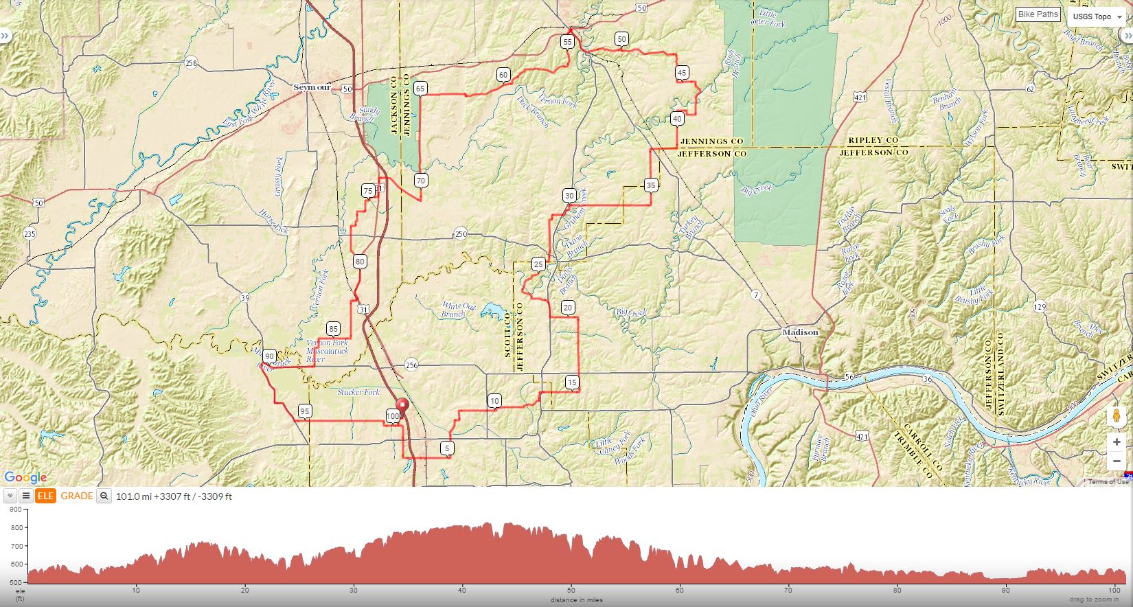
| Christy Century Scotsburg to North Vernon and Back 101.0 Miles, Total Climb 3309, 33 Ft/Mile by Melissa "Puddle" Hall |
||
Mile |
Turn |
Road |
0.0 |
R |
Out of Parking Lot on Community Way |
0.2 |
L |
Wilson Road (SS) |
0.6 |
BL |
Weir Road |
1.6 |
X |
State Rd . 56 (SS) |
2.6 |
L |
Lake Road West (SS) |
3.6 |
X |
State Road 31 (becomes Lovers Lane) Stop Light |
5.2 |
L |
Double or Nothing (150 E) (SS) |
6.2 |
X |
State Road 56 to Slate Cut Road (SS) |
7.3 |
R |
Grain Bin Road (50N) |
7.5 |
L |
Terry Road |
8.0 |
R |
Blocher Road (100N) |
9.6 |
X |
State Road 203 (SS) |
11.7 |
L |
at T to continue on Blocher Road (550E) |
12.8 |
L |
Railroad Street |
13.2 |
R |
Polk Road (AKA North Street, Blocher N) (SS) |
13.3 |
X |
State Road 3 (SS) |
15.3 |
L |
1233 W |
17.9 |
X |
State Road 256 to 1250 (SS) |
19.4 |
L |
Blake Road (SS) |
20.9 |
R |
State Road 3 (SS) |
21.8 |
L |
Deputy Pike/Main Street |
22.7 |
R |
N1500 (T) |
23.5 |
S |
Dixon Ford (250 becomes 1100S |
26.3 |
X |
State Rd. 250 to 200 W/Tate (SS) |
28.4 |
L |
Byfield (Town of Commiskey) |
28.6 |
R |
Main Street/850 S (SS) |
29.1 |
R |
Store/Deene's Country Store (no bathroom) |
29.1 |
X |
State Road 3 to 115 W |
29.9 |
R |
800 S/becomes 900N (NO SIGN/SCHOOL AT INTERSECTION) |
34.3 |
L |
Jake Gayle Road (SS) becomes Addleman (Gravel) |
37.4 |
R |
500 S (SS) |
37.5 |
X |
State Road 7 (SS) |
38.8 |
L |
500 E/becomes 300/500/325 |
42.2 |
L |
600 E/Grayford (SS) becomes 640 E |
44.2 |
L |
150 E/Grayford |
45.2 |
R |
500 E/becomes 300/500/325 |
46.7 |
L |
20N (T) |
49.9 |
L |
25N |
51.0 |
L |
40 N (SS) |
52.0 |
R |
State Road 7/3 (SS) BUSY |
53.4 |
X |
State Road 50 (Stop Light) |
53.5 |
R |
Main Street |
53.6 |
R |
BURGER KING LUNCH STOP |
R |
out of lunch top the way you were going |
|
53.7 |
R |
Unnamed street right next to Burger King |
53.8 |
R |
State Road 50 (Stop Light) |
53.9 |
X |
State Roads 3/7 (stop Light) |
54.1 |
L |
Norris (Stop Light) |
55.8 |
R |
60S/becomes 70/350/130 |
59.5 |
R |
150 S/becomes 200/215 |
62.3 |
L |
200 S (NO SIGN) |
64.8 |
L |
900 W (SS) |
70.5 |
R |
Commiskey Pike (SS) |
73.2 |
L |
State Road 31 (SS) Busy |
74.2 |
R |
50 S |
75.0 |
L |
112E (SS) becomes 1100 |
75.7 |
R |
125 S |
76.1 |
L |
on 1060 |
76.9 |
R |
200S (SS) becomes 1025 |
77.7 |
X |
State Road 250 (SS) |
79.3 |
L |
400 S (SS) |
79.5 |
R |
State Road 31 (SS) BUSY |
80.9 |
L |
Into STORE (FAS STOP GAS STATION) |
out of store on 31 the way you were going |
||
81.6 |
R |
Main Street |
82.0 |
L |
Bethany (SS) becomes 1025 |
84.0 |
R |
800 S/becomes 850 E |
87.5 |
R |
State Road 256 (SS) |
90.4 |
L |
State Road 39 (SS) |
92.8 |
L |
to continue on State Road 39 (SS) |
94.4 |
L |
Washington (becomes Little York Road) |
99.3 |
R |
Boatman Road (SS) |
99.5 |
L |
Weir Road |
100.3 |
L |
CR 125/Wilson Road (SS) NO SIGN |
100.8 |
R |
W. Community Way (SS) |
101.0 |
L |
Into Parking Lot |
Download Printer-Friendly Cue Sheet Here
Interact With Map or to download GPS Route