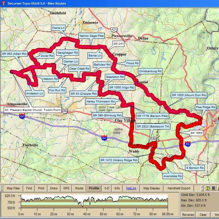
| 6010 - Pea Ridge or Bust 88.9 mi, Cumulative Climb: 5937 ft, avg: 67 ft/mile Start: Mt. Pleasant Baptist Church, Todd's Point, KY Michael Crawford |
||
| Miles | Turn | Road |
| 0.0 | Start | Todd's Point - Mt Pleasant |
| 0.0 | R | out of Parking lot on to 362 |
| 0.8 | S | at 4 way stop on to |
| 4.0 | L | at T stop sign on to |
| 6.5 | R | at T stop on to 362 |
| 7.2 | L | |
| 9.3 | R | |
| 12.2 | L | SR 53 |
| 12.5 | R | SR 322 ( |
| 13.2 | R | |
| 16.5 | R | SR 55 (Eminence Pike) |
| 17.2 | L | Narrow Gage Pike |
| 18.2 | S | at intersection |
| 20.0 | L | SR 1899 (Mulberry Pike) No Sign! |
| 20.1 | R | |
| 20.9 | R | SR 241 ( |
| 22.3 | L | SR 43 |
| 22.4 | R | Flood Rd |
| 24.5 | L | |
| 28.0 | R | at T stop sign on to 395 |
| 28.4 | L | at T Stop/RR Xing on to SR 12 ( |
| 29.3 | L | at stop to stay on Hw 12 |
| 29.3 | R | immediately on to |
| 32.6 | L | at stop (steep downhill) on to1005 |
| 33.2 | R | at stop to stay on 1005 |
| 39.3 | L | |
| 43.1 | L | at T stop on to SR 1665 ( |
| 45.1 | X | US 60 (caution) |
| 45.2 | R | at T stop on to 1665 ( |
| 45.2 | L | immediately to stay on 1665 |
| 46.8 | R | |
| 49.1 | X | 151 (Caution). Becomes Avenstoke |
| 51.6 | R | |
| 53.6 | R | SR 1472 |
| 56.1 | L | SR 2823 (Bardstown Trl) |
| 59.6 | R | SR 395 ( |
| 61.7 | X | US 60 (caution) |
| 61.9 | S | at intersection. Stay on 395 |
| 64.9 | L | SR 1779 (Benson Pike) |
| 66.3 | R | |
| 68.1 | L | SR 1005 ( |
| 70.6 | R | |
| 72.4 | L | SR 12 ( |
| 73.0 | R | SR 43 ( |
| 74.2 | L | |
| 74.4 | S | at intersection to stay on |
| 77.2 | R | |
| 78.7 | R | SR 55 (Eminence Pike) |
| 79.3 | L | |
| 81.0 | R | Orphan Ln |
| 82.9 | L | |
| 84.1 | L | SR 53 ( |
| 84.5 | R | SR 362 ( |
| 88.1 | R | SR 362 at 4 way stop |
| 88.9 | L | into Parking Lot |
Map Images are copyright © 2004 Delorme, TOPO USA ® and are provided pursuant to their End User Licensing Agreement. Visit http://www.delorme.com for more information.