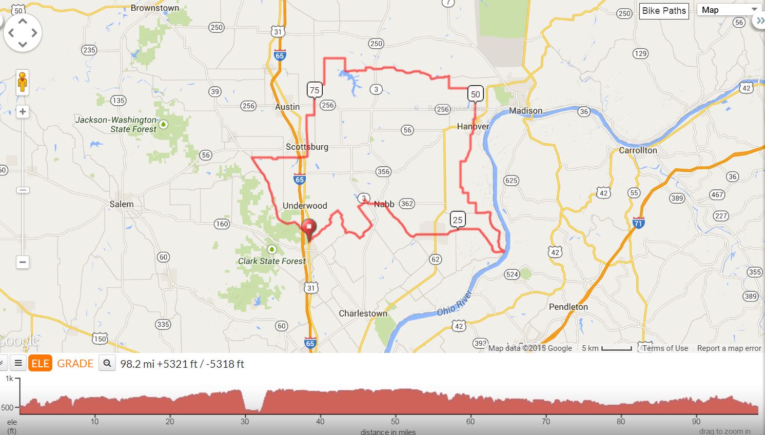
Quest for Bethlehem is a moderate century with one significant climb but otherwise flat to rolling hills. It is scenic with low traffic roads through most of the course. Each time we have ridden this century, it has been right before Christmas with some of us taking the opportunity to get a Bethlehem postmark on our bundles of Christmas cards. Each time we have ridden the century, it has been on a cold rainy day, adding to the challenge but enthusiastically embraced by Puddle, our ride captain, who enjoys riding in the rain. Even so, it has been a great ride. Think how pleasant it could be on a warm Sunny day!
|
5512 - Quest for Bethlehem Centuryby Melissa"Puddle" Hall |
||
| Mile | Turn | Road |
Right out of parking lot |
||
.21 |
L |
Hwy. 31 N (SS) |
.47 |
R |
Hebron Church Road |
4.9 |
R |
Dieterlan Road (SS) |
5.5 |
R |
Dieterlan Road (SS) |
7.4 |
L |
Henryville/Otisco Rd. (SS) |
9.1 |
bear L |
Henryville/Otisco Rd. |
9.5 |
L |
Old State Rd. 3 (SS) |
10.9 |
L |
Mahan (SS) (Caution) |
13.1 |
R |
Church Road |
14.2 |
R |
S. State Rd. 3 (SS) |
14.7 |
L |
E. State Rd. 362 |
16.2 |
R |
Nabb/New Washington Rd. W |
19.6 |
R |
Harry Bower |
19.7 |
L |
Nabb/New Washington |
22.8 |
X |
Hwy. 62 (SS) Store stop 1 |
22.9 |
R |
E. Main out of store |
22.9 |
(Store stop 2 on right) |
|
23.5 |
E. Main becomes Bethlehem/New Washington |
|
31.05 |
L |
Riverview Alley to river |
31.1 |
R |
No sign. Take to river. |
31.1 |
R No Sign (Take to river) |
|
31.2 |
L |
Bell Street |
31.6 |
bear R |
Miles Rd. (No sign) |
34.2 |
R |
Marble Hill Road |
37.1 |
R |
S. Paynesville Road |
38.2 |
bear L |
S. Paynesville (W. 900 S.) |
38.8 |
Continue on S. Paynesville |
|
39.5 |
L |
Reed/W. Jackson Rd. |
40.3 |
R |
S. Saluda/Paynesville |
42.4 |
becomes S. Hanover/Saluda Rd. |
|
43.6 |
R |
W. Reardon |
44.1 |
L |
S. Hanover/Saluda Rd. |
46.7 |
bear R |
S. Hanover/Saluda |
46.9 |
becomes S. Main Cross |
|
47.7 |
L |
W. Main (Subway Store Stop) |
47.9 |
L |
W. Main out of Subway |
47.9 |
R |
Hwy. 56 (SS) |
48.2 |
L |
Thorton Road (SL) |
48.7 |
R |
W. Kuntz (SS) |
48.9 |
L |
S. Grange Hall Rd. |
49.9 |
X |
W. SR 256 |
51.4 |
road becomes N. 450 W |
|
52 |
L |
W. Chicken Run |
54.6 |
R |
N. Thompson (SS) |
55.8 |
L |
W. Deputy Pike (SS) |
63.6 |
X |
Hwy. 3 (SS) |
Becomes W. Main Street |
||
64.5 |
L |
N. 1500 W. |
64.8 |
becomes W. 366 N |
|
65.8 |
becomes Quick Creek |
|
66.9 |
R |
N. Sunnyside |
68.1 |
L |
Peacock (SS) |
70.1 |
L |
N. Terry (SS) |
72.6 |
R |
E. Harrod (SS) |
73.6 |
L |
N. Bogardus (SS) |
75.6 |
X |
E. St. Rd. 256 (SS) |
Becomes N. Slab |
||
76.6 |
R |
Cutshall |
77.3 |
L |
N. Main Street |
80.3 |
L |
Hwy. 56 |
80.4 |
R |
N. First Street |
80.5 |
R |
Wardell |
80.6 |
L |
W. Main (SS) |
81.5 |
R |
Lovers Lane |
Becomes W. Lake Rd. W |
||
81.8 |
X |
Hwy. 31 S (Lite) |
Store stop Caseys |
||
L |
out of store on W. Lake |
|
82.8 |
L |
S. Lake Rd. S. (SS) |
82.8 |
R |
W. Lake Rd. W |
87.1 |
L |
S. Zion/Bloomington Trail |
94.6 |
becomes Brownstown |
|
97.6 |
R |
Hwy. 31 (SS) |
98.2 |
R |
Into forestry |
98.4 |
L |
into parking lot |
Click on map below to interact with map