"Puddle" got her name because she prefers to ride in the rain. Not long ago, she showed up for a club century ride that was cancelled because of steady rain. None of the boys wanted to take it on. Never mind, Melissa did the whole century solo, and in the rain, thus earning her moniker "Puddle" and firmly establishing herself as one of the maddest of the Mad Dogs of the Louisville area. Now, enjoy a century route of Puddle's own creation.
Puddle's Medora Century |
||
0 |
L |
Out of parking lot |
0.6 |
L |
First Road after cross I-65 |
0.7 |
L |
New Franke (T) |
2 |
R |
At T toward park entrance |
2.3 |
R |
At T toward park entrance |
3.8 |
L |
Hwy. 31 North (SS) |
4 |
R |
Hebron Church Road |
8 |
L |
Beagle Club Road (SS,T) |
12.1 |
R |
Hall's Corner Road |
13.1 |
S |
Underwood Road (SS) |
14.3 |
R |
Radio Tower Road (SS) |
15.1 |
L |
Double or Nothing Rd. (SS) |
19.7 |
X |
Hwy. 56 to Slate Cut (SS) |
20.8 |
L |
Grain Bin Road (SS) |
21.5 |
R |
Slab Road (SS) |
23.5 |
L |
Cutshall Road (No Sign) |
24.8 |
L |
Coffee Pot Curve (SS) |
25 |
R |
Hwy. 31 North (SS) busy road |
26.5 |
L |
Hwy. 256 W (Stop Light) |
26.5 |
L |
Huck's Store Stop |
L out of store on 256 W. |
||
33.9 |
R |
Hwy. 39 N (SS) |
40.8 |
S |
400 S (Easy to miss, look for R Ranch) |
42.9 |
R |
50 E (SS) |
46.8 |
L |
275 W (SS) |
47.3 |
R |
450 S |
48.5 |
R |
135 N (SS) |
49 |
L |
Rd. 235 |
52.6 |
R |
to continue on 235 (SS) |
53 |
L |
Main Street |
Deli Store Stop on immediate right |
||
Back the way you came on 235 |
||
55.9 |
R |
460 W (Becomes 500) |
58 |
L |
600 S (Becomes 650,700) |
68.4 |
R |
Hwy. 39 South |
74.9 |
Store Stop on Right |
|
74.9 |
R |
out of store on 39 |
76.6 |
X |
Hwy. 56 to Slate Cut (SS) |
76.7 |
L |
Old 56 (SS & T) |
Becomes Bloomington Trail |
||
77.9 |
S |
West Lake Road (SS) |
82.3 |
R |
S. Lake Road (SS) |
84.1 |
L |
Leota Road (SS) |
85.3 |
S |
356 E (Cross 31) (SS) |
85.9 |
R |
Underwood Rd. |
88 |
L |
Radio Tower Road (SS) |
88.8 |
R |
Double or Nothing Rd. (SS) |
becomes Werewolf, then Kinderhook |
||
91.8 |
R |
Slate Ford Road (becomes Saw Mill) |
93.2 |
R |
Beagle Club Road (SS) |
93.2 |
L |
Hebron Church Road (No sign) |
97.7 |
L |
Hwy. 31 South |
97.8 |
R |
Into Forestry |
98.2 |
L |
Parking Lot |
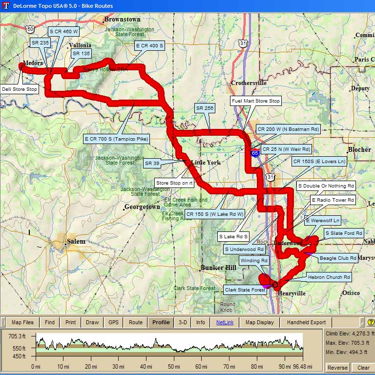
Map Images are copyright © 2006 Delorme, TOPO USA ® and are provided pursuant to their End User Licensing Agreement. Visit http://www.delorme.com for more information.