Louisville Bicycle Club "Mad Dogs" accept no limits to the "mindless mileage" they accumulate. If there isn't an official century ride on the schedule, they will just make one up and go--even though they receive no club mileage credit and the weather may be far from perfect. Nine of us showed up for more mindless (but joyful) miles at "Mad Dog" Melissa "Puddle" Hall's house on December 12, 2004 for a 100 miles of pure unadulterated insanity and fun.
"Puddle" got her name because she prefers to ride in the rain. Not long ago, she showed up for a club century ride that was cancelled because of steady rain. None of the boys wanted to take it on. Never mind, Melissa did the whole century solo, and in the rain, thus earning her moniker "Puddle" and firmly establishing herself as one of the maddest of the Mad Dogs of the Louisville area.
Now, enjoy a century route of Puddle's own creation. Too bad (for her) it didn't rain the day we rode this ride. She had to settle for very windy and cold. You, of course, can pick your own weather for this scenic and delightful ride. (If you park at the firehouse, just let them know your plans first. The person to contact about using the fire house is Jim Moon. The work number is 812-752-4501 )
Puddle told us all that the ride was flat! As you can see, it certainly is not flat! Later she admitted that she had just been "fibbing" a little. I told her that if she had fibbed much more, we all would have required defibrillators! Enjoy.
Puddle Century |
||
|
L |
|
|
|
1.2 |
L |
on Little |
|
4.1 |
R |
SR 39 N. (SS) |
|
5.7 |
S |
|
|
7.1 |
R |
|
|
7.3 |
L |
|
|
9.5 |
L |
|
|
14.9 |
S |
|
|
19.4 |
R |
Nicholason Hollow (SS) |
|
19.5 |
L |
|
|
24.0 |
L |
SR 135 (SS) |
|
24.1 |
R |
|
|
R |
RED BARN Store Stop |
|
|
L |
out of store |
|
|
L |
SR 135 (SS) |
|
|
24.3 |
L |
|
|
26.5 |
R |
|
|
|
||
|
32.4 |
L |
|
|
34.1 |
R |
|
|
35.5 |
L |
|
|
37.0 |
L |
|
| 37.1 | BR | Coon Hunter Road |
38.5 |
R |
|
39.8 |
L |
|
40.5 |
BL | (Turns into Sycamore at Campbellsburg.) |
|
42.4 |
X |
across SR 60 |
|
(Sycamore becomes |
||
|
46.3 |
R |
Mt. Taber Rd. (SS) |
|
46.9 |
L |
Campbellsbg./Livonia |
|
( |
||
|
49.7 |
L |
SR 56 |
|
49.9 |
R |
Hardinsburg/Livonia |
|
L |
Dutch Barn Lunch Stop at Intersection |
|
|
49.9 |
L |
out of Dutch Barn on H-Burg/Livonia |
|
52.5 |
L |
Posey |
|
58.3 |
L |
|
|
64.1 |
R |
Beck's Mill Rd (Curves right) |
|
66.7 |
L |
SR 60/135 (SS) |
|
67.7 |
X |
SR 56 E (BUSY) |
|
68.0 |
L |
CHEDDAR DEPOT Store Stop |
|
|
L |
out of store on 135 |
|
70.2 |
R |
|
|
71.8 |
L |
|
|
72.8 |
R |
|
|
76.2 |
L |
to continue on Delaney (Delaney turns to |
|
86.1 |
R |
|
|
88.4 |
S |
Short Cut |
|
(Turns to Pumpkin C. E.) |
||
|
90.0 |
L |
New Cut (SS) |
|
91.5 |
L |
|
|
93.0 |
R |
39 S (SS) |
|
94.6 |
L |
Wasthington (becomes Little
|
|
97.4 |
R |
|
|
98.6 |
R |
into firestation |
Interact with map or to get a downloadable GPS file. (Use the "Overview" tab and the "Export" tab to get the download.)
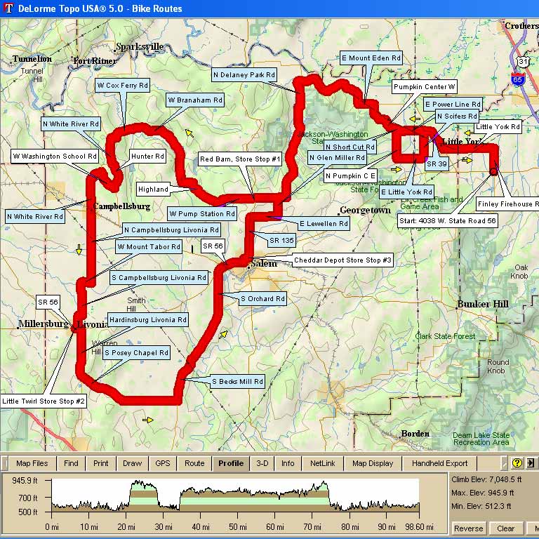
Map Images are copyright © 2006 Delorme, TOPO USA ® and are provided pursuant to their End User Licensing Agreement. Visit http://www.delorme.com for more information.