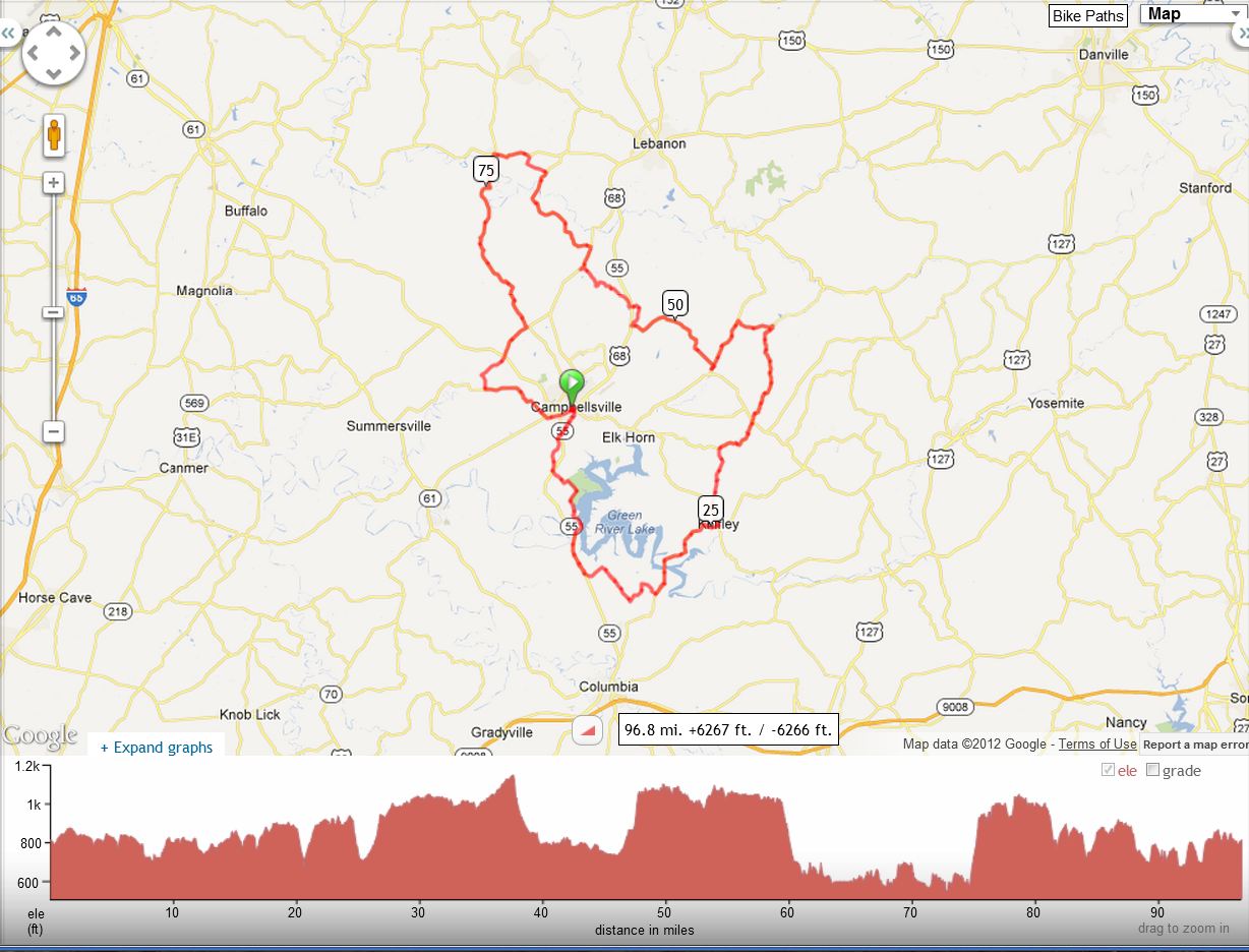
A beautiful tour of south-central Kentucky, going past Green River Lake and on through Taylor, Adair, Casey, and Marion counties. Starts at Campbellsville University.
96.8 Green River Mad Dog Century |
|||
Miles |
Turn |
Road |
Leg |
0.0 |
R |
Columbia Av (3183) |
1.8 |
1.8 |
X |
55 (at SL), continue on 3183 |
2.6 |
4.4 |
L |
1061 |
0.1 |
4.5 |
X |
55 (at SS), continue on 1061 Follow this road past the Green River Lake State Park entrance, across the dike, spillway, and dam |
5.4 |
9.9 |
L |
55 (at SS), busy road! |
2.5 |
11.9 |
Adair Co Line |
||
12.4 |
L |
682 (at Coburg) |
0.4 |
12.8 |
L |
to stay on 682 |
0.9 |
13.7 |
R |
to stay on 682 (at SS) |
2.6 |
16.3 |
L |
2971 (at T) |
1.4 |
17.7 |
R |
West Egypt (turn at bottom of hill) |
1.1 |
18.8 |
L |
551 (at T, unsigned) |
6.7 |
20.5 |
X |
Cross Green River Lake |
|
25.5 |
STOP |
on L: Crossroads Store (in Knifley) |
|
25.5 |
L |
76 (take the left exit from the lot) |
1.6 |
27.1 |
R |
Eastridge Cemetery Rd |
1.3 |
28.4 |
L |
Roley Yuma Rd (at T) |
0.1 |
28.5 |
R |
Eastridge Cemetery R--Into Taylor Co, following the Adair then Casey Co borders for the next 5 miles |
1.9 |
30.4 |
R |
1752 (at SS, at water tower) |
3.1 |
33.5 |
X |
70 (at SS), continue on 659 |
4.0 |
37.5 |
S |
Raikes Hill Rd (at church) |
2.5 |
40.0 |
L |
to stay on Raikes Hill Rd |
0.1 |
40.1 |
L |
Merrimac Rd |
2.3 |
42.4 |
L |
337 |
3.4 |
45.8 |
STOP |
on L: Penn Store & Restaurant (in Mannsville) |
|
45.8 |
Reverse direction: back on 337 |
0.3 |
|
46.1 |
L |
744 |
6.9 |
47.2 |
S |
Climb hill, 0.4 mile, max 12% grade |
|
53.0 |
R |
208 (just before intersection w/ 68) |
1.4 |
53.7 |
S |
Marion Co Line |
|
54.4 |
L |
Minnie Brown Rd--back into Taylor Co, then along the Marion Co border for the next 9 miles |
0.3 |
54.7 |
X |
68 (at SS), straight on Finley Ridge Rd |
3.0 |
57.7 |
R |
to stay on Finley Ridge Rd (at T)-into Marion Co |
1.7 |
59.4 |
R |
289 (at SS, in Finley) |
1.7 |
61.1 |
L |
412 (in Jessietown) |
5.9 |
67.0 |
STOP on L: St Joe Grocery (in St Joe) |
||
67.0 |
Continue north on 412 |
1.4 |
|
68.4 |
L |
Sallie Ray Pike |
1.3 |
69.7 |
R |
to stay on Sallie Ray Pk (at T) |
0.6 |
70.3 |
L |
84 (at T) |
2.0 |
72.3 |
S |
to join 527 (in Raywick) |
12.8 |
72.5 |
S |
To stay with 527 when 84 turns right |
0.2 |
74.6 |
Climb Scott Ridge, 0.9 mile, max 12% grade |
||
76.3 |
Enjoy Horseshoe Bend Overlook |
||
78.8 |
Water fill-up at Mt. Washington Bapt. Church; spigot is along front wall |
||
79.8 |
Taylor Co line |
||
85.1 |
R |
744 (at SS) |
2.3 |
87.4 |
X |
210 (at SS), continue on Fallen Timber |
1.9 |
89.3 |
L |
across the bridge, then hard L up the hill to stay on Fallen Timber--get into a low gear by the bridge! 0.4 mile, max 9% grade |
1.0 |
90.3 |
L |
323 (at T) |
2.5 |
92.8 |
R/L |
to continue on 323 |
2.1 |
94.9 |
X |
68 (at SL), continue on Main St |
1.7 |
96.6 |
L |
Columbia Av (3183) (at SL) |
0.2 |
96.8 |
L |
into Parking Lot at C.U. |
|
Click Map to Interact with Map