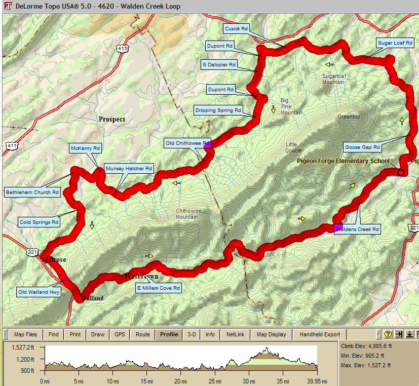
Walden Creek Loop by Chad Green 39.8 mi, Cumulative Climb: 4806 ft, avg:116 ft/mile |
||
| 0.0 | L | Waldens Creek Rd |
| 0.1 | L | Goose Gap Rd |
| 4.5 | L | Sugar Loaf Rd (Caution-blind curve) |
| 8.0 | L | Cusick Rd (Very narrow road) |
| 8.7 | R | S Rodger Rd @ SS |
| 9.5 | L | Dupont Rd @ SS |
| 10.2 | BR | S Delozier Rd |
| 10.9 | L | Dupont Rd |
| 11.5 | R | Dripping Springs Rd @ SS |
| 14.2 | L | Old Chilhowee Rd |
| 14.8 | BR | to stay on Old Chilhowee Rd |
| 18.0 | R | Munsey Hatcher Rd |
| 19.4 | L | McKenry Rd @ SS |
| 19.5 | L | Bethlehem Church Rd |
| 20.5 | L | Bethlehem Rd @ SS |
| 21.4 | L | Cold Srings Rd @ SS |
| 22.2 | R | Cold Springs Rd (narrow road) |
| 23.2 | S | Cold Springs Rd |
| 24.4 | L | Old Walland Hwy @ SS |
| 26.2 | L | Old Walland Hwy @ SS (or store, see below) |
| Store | Right @ SS, go across bridge to store | |
| 26.3 | L | E Millers Cove Rd |
| 32.5 | S | becomes Waldens Creek Rd |
| Caution: rough road on downhill | ||
| 39.8 | L | Into school parking lot |
 Map Images are copyright © 2004 Delorme, TOPO USA ® and are
provided pursuant to their End User Licensing Agreement. Visithttp://www.delorme.com for more
information.
Map Images are copyright © 2004 Delorme, TOPO USA ® and are
provided pursuant to their End User Licensing Agreement. Visithttp://www.delorme.com for more
information.