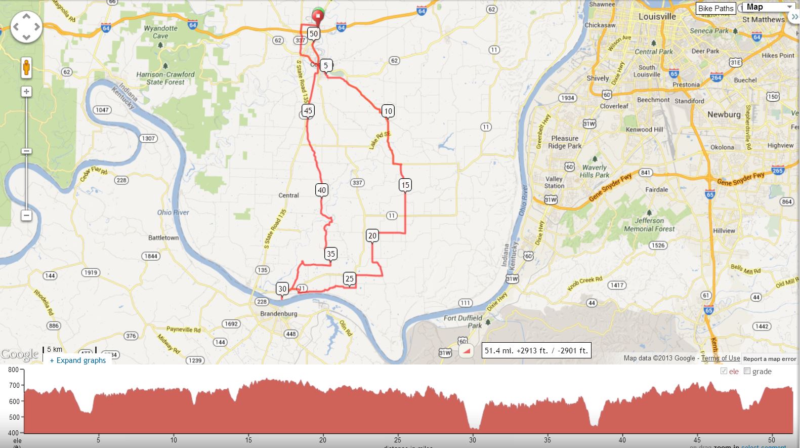
MORGAN’S RAID –Day 1 (Battle of Corydon Loop) Cue starts at light/Hwy 135 & Sky Park by Shell Station (Corydon IN) |
||
Mile |
Turn |
Route |
0 |
X |
at light to Quarry Rd |
1 |
L |
Corydon-Ramsey Rd |
1.9 |
X |
blinking light at Hwy 135 |
2.7 |
L |
Hwy 62 |
2.8 |
X |
at light to stay on Hwy 62 |
3.9 |
Emery's Ice Cream on left |
|
4 |
R |
Capitol Ave (Hwy 62/ 337) |
4.1 |
L |
Chestnut St. |
4.1 |
Butt Drugs Old Fashioned Soda Counter on right |
|
4.2 |
R |
Mulberry St (cross over slab bridge) |
4.4 |
BL |
Beech St (climb hill, grades up to 17-18%) |
5.2 |
L @SS |
Country Club Rd (unsigned) |
6.5 |
R |
Corydon-New Middletown Rd |
9.3 |
L |
To stay on Corydon-New Middletown Rd |
9.8 |
L |
Clay St |
9.9 |
R |
3rd St |
10 |
X @SS |
3rd becomes New Middleton-Elizabeth Rd. |
13.1 |
R |
Pumping Station Road |
16.2 |
X |
Hwy 11 |
16.2 |
S |
N Rehobeth Rd |
17.2 |
R |
Old Goshen Rd |
19.2 |
L |
Kintner Bottom Rd |
20.7 |
X |
at stop sign (road unsigned) |
22.2 |
R |
E. Laconia Rd |
23.7 |
STOP |
Laconia General Store – south/right –CROSS Hwy11 down hill out of store on N. Tobacco Landing Rd (unsigned) |
24.4 |
R |
Scenic View Drive |
26.1 |
L @ T |
to stay on Scenic View |
28.3 |
L |
Hwy 11 |
28.7 |
Hard R* |
*Otterbein Rd - SHORTCUT ONLY - DO NOT turn here if you wish to view river crossing |
29.5 |
L |
Morgan's Landing (easy to miss at bottom of hill/unsigned) |
29.5 |
JHMHT#2 |
Historical Marker - Morgan's Landing – rough pavement and loose gravel to river’s edge |
30.5 |
Backtrack |
to Hwy 11 and back up hill |
31.1 |
L |
Otterbein Rd (look for JHMHT sign) |
33.4 |
S |
at stop sign |
36.9 |
BL |
to stay on Otterbein Rd |
37.9 |
JHMHT#3 |
Historical Marker - Frakes' Mill |
38 |
L |
Union Chapel Rd |
39 |
R @ T |
to stay on Union Chapel Rd |
39.9 |
Tindall School House No. 3 (Circa 1857) |
|
43.3 |
X |
at stop sign |
44.5 |
R |
Old Hwy 135 |
45.9 |
X |
at stop sign |
47.4 |
R |
Battle of Corydon Park |
47.5 |
R |
out of Park to continue on Old Hwy 135 |
(Caution) Steep Downhill |
||
48.4 |
R |
Beaver St (around town square) |
Recommended Lunch Option-Frederick's |
||
48.5 |
L |
Walnut St |
48.5 |
JHMHT#4 |
Historical Marker - Historic Corydon |
48.6 |
R |
Capitol Avenue/Old Hwy 135 |
50 |
BR |
Hwy 135 |
51 |
R |
Sky Park at Shell Station/ Comfort Inn |
S=Straight X=Cross BL=Bear Left BR=Bear Right SS=Stop Sign Kirk’s Cell (502) 718-1911 Cathy’s Cell (859) 509-4425 |
||
Interact with Map or Download GPS Route