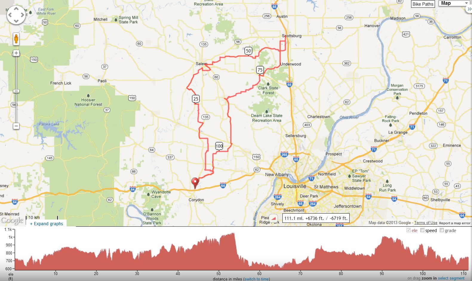
4440 - Give Me Liberty (Old Version) Start - Frisch’s, Corydon Indiana |
||
Mileage |
Turn |
Route |
0.0 |
R |
Hwy 135 |
0.1 |
R |
Old State Road 135 (caution- angled RR tracks ahead) |
1.9 |
R |
Hwy 135 |
2.4 |
R |
Hwy 335 |
6.0 |
L |
Motts Road |
7.9 |
R |
Oak Park Road |
9.2 |
X |
State Road 64 |
9.8 |
X |
Whiskey Run Rd |
11.2 |
R@T |
Flatwood Rd (Alpacas ahead) |
12.1 |
L |
School Rd |
13.0 |
X |
Bradford Lane |
13.6 |
R |
Gettlefinger Rd (Unsigned) (after sharp left curve) |
14.6 |
L |
Old East Rd/Gettlefinger |
16.0 |
BR |
At SS |
16.3 |
R |
Hwy 135 (Busy) |
17.5 |
X |
Hwy 150 (Busy – Palmyra) |
19.6 |
L |
Palmyra Lake Rd |
20.7 |
R |
Big Springs Rd |
21.4 |
S |
@ SS |
23.1 |
L |
@ SS to stay on Big Springs |
24.4 |
L |
Grandview |
25.2 |
R |
Horners Chapel Rd |
25.3 |
BR |
Wills Road at fork |
26.4 |
BL |
To stay on Wills Road |
26.9 |
L |
Vincennes Trail |
30.2 |
R |
S Becks Mill Rd |
33.2 |
BR |
W Beck’s Mill Rd |
35.7 |
R |
Hwy 135 (Caution) |
36.1 |
L |
Salem Bypass |
37.8 |
L |
Hwy 60 (Caution) |
38.6 |
STOP |
Marathon-Cowboy’s on right DQ on left as alternative stop |
38.6 |
L |
Old SR 160 (behind Marathon) |
39.4 |
R |
Fair Street @ SS |
39.5 |
R |
Market Street |
40.9 |
L |
Heritage Chapel Rd |
41.4 |
R |
Day Rd |
43.2 |
L@T |
N Canton Rd |
43.8 |
R |
E Canton Rd (Unsigned) @ corner of closed store |
44.9 |
L |
N Howell Rd (Unsigned) |
45.0 |
BR |
New Philadelphia Rd at fork (Unsigned) |
45.9 |
BR/BL |
To stay on New Philadelphia |
50.4 |
L |
To stay on New Philadelphia |
50.7 |
BR |
To stay on New Philadelphia |
51.3 |
L |
New Salem/Finley Knob Rd |
51.7 |
R |
New Salem/Finley Knob Rd |
53.4 |
BR |
Leota Rd (caution-downhill)) |
54.8 |
BR |
To stay on Leota Rd |
55.8 |
S |
Covered Bridge |
56.0 |
BL |
To Stay on Leota Rd |
59.2 |
L |
S Lake Road (Co. Rd. 100W) |
62.0 |
R |
Hwy 56 @ light |
62.1 |
LUNCH OPTIONS |
Arbys-McDonald’s–Wendys on left in Scottsburg |
62.1 |
R |
Highway 56 (backtrack) |
62.3 |
L |
Lake Rd @ light |
63.3 |
R |
W Lake Rd |
65.3 |
L |
Boatman Rd/Co Rd 200W |
70.0 |
S |
W Salem Rd at SS (turns into Liberty Knob) |
74.0 |
R |
Hwy 160 |
74.9 |
L |
S Blue River Rd |
79.5 |
BL |
To stay on E Blue River Rd |
79.7 |
BR |
To stay on E Blue River Rd |
80.9 |
BR |
To stay on Blue River Rd |
83.4 |
BR |
Stay on Blue River |
85.9 |
R |
Main St at SS |
86.2 |
BL |
Cross Railroad Tracks |
86.2 |
X |
Highway to store |
86.2 |
STOP |
NEWTON’S GROCERY-Pekin |
86.2 |
Back-Track |
Go back across tracks & follow E Main SE out of town |
86.8 |
S |
Over bridge (Caution-Wood Planks) |
87.2 |
L |
At SS on Jefferson Street |
87.4 |
R |
Co Rd 550 E/Voyles Rd |
87.8 |
X |
Hwy 60 |
90.5 |
BL |
Voyles Rd at SS |
90.6 |
BR |
To stay on Voyles Rd |
96.0 |
L |
Clark St (1 block before hwy) |
96.2 |
R |
Cross Street |
96.3 |
X |
Hwy 150 (Caution) |
96.3 |
S |
Greenville-Georgetown Rd |
98.0 |
R |
Nadorff Rd |
101.4 |
L |
Walk Rd |
102.6 |
X |
Whiskey Rd at SS |
103.9 |
L |
Hwy 64 (Caution) |
104.1 |
R |
Hwy 335 |
108.6 |
L |
Hwy 135 |
109.1 |
L |
Old Hwy 135 |
111.0 |
L |
Hwy 135 |
111.1 |
L |
Sky Park @ light to Frisch’s |
Kirk’s Cell (502) 718-1911 Cathy’s Cell (859) 509-4425 |
||
L=Left R=Right BL=Bear Left BR=Bear Right S=Straight X=Cross SS=Stop Sign |
||
Interact with Map or Download GPS File