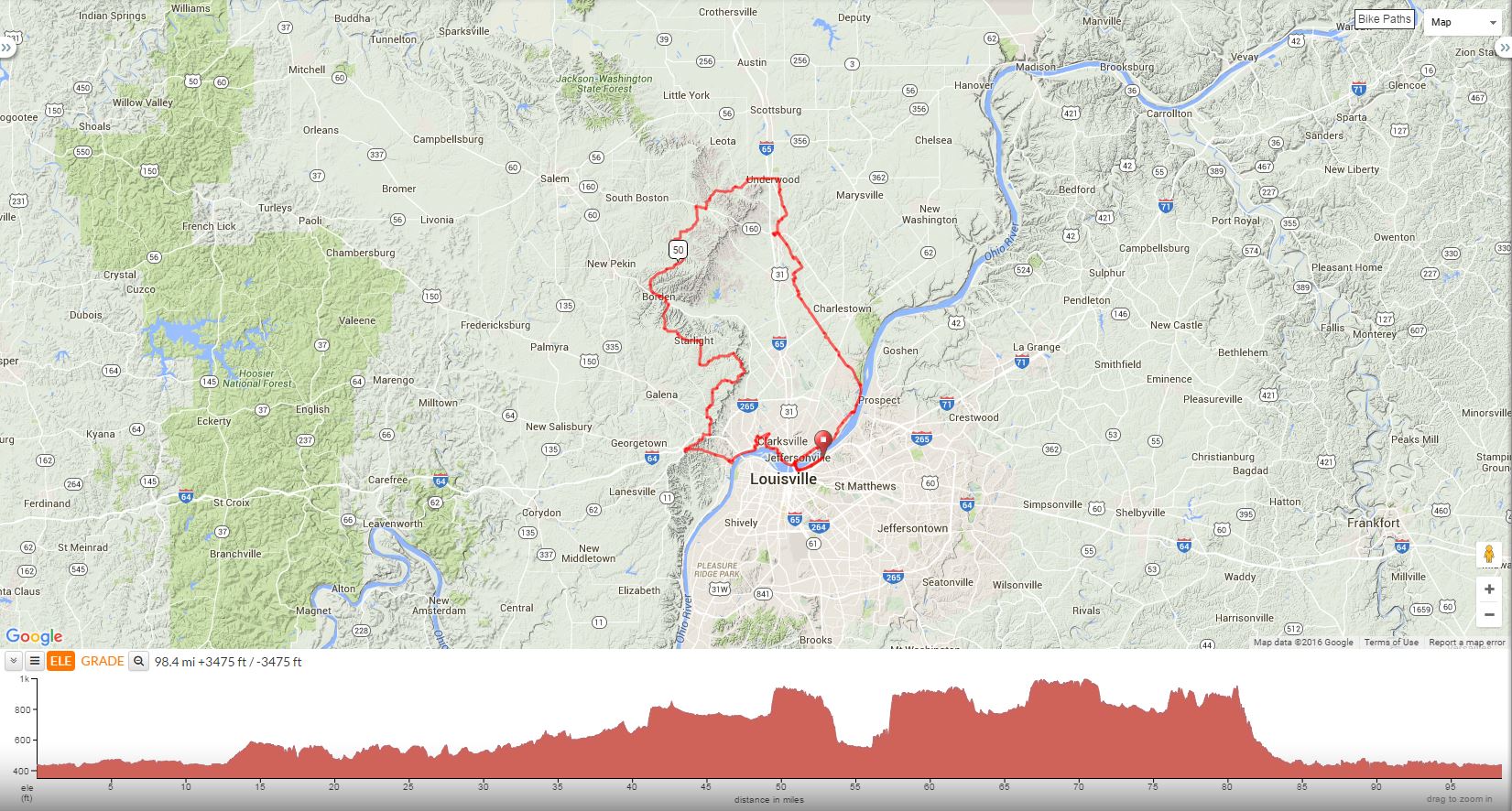
Adjective Ride
This ride begins at the site of the famous Louisville Water Tower on Zorn and passes through Indiana towns to the north including Underwood, New Liberty, Borden and Starlight. On July 31, 2016, parking for this ride was listed as Ramada Inn North at 1041 Zorn; however, the mileage starts at the interesection of Zorn and River Road.
Start at Zorn Ave and River Road, Louisville, KY 40207
The Adjective Ride |
||
Miles |
Turn |
Road |
0.0 |
R |
Out of Water Company onto River Road |
2.3 |
R |
Onto Big4 bridge |
3.3 |
L |
Pearl St with immediate right shown below |
3.3 |
R |
Immediate right on W Chestnut st. |
4.2 |
S |
Road becomes Park Place |
5.5 |
R |
Ewing Lane |
6.0 |
L |
Utica Pike |
9.8 |
R |
Church Street |
10.0 |
L |
Bends left into S Front Street |
10.7 |
R |
Upper River Road |
12.4 |
L |
Paul Garrett Avenue (no sign) |
12.4 |
R |
Quick Rt (no sign) @ entrance Quarry Bluff |
15.8 |
S |
Cross Hwy 62 onto Bethany Road |
18.6 |
S |
Cross Hwy 402 onto Stoney Point Road |
21.6 |
R |
Fox Road |
21.8 |
L |
Trealor Road |
23.1 |
R |
Hansberry Road |
23.4 |
L |
To stay on Hansberry Road |
25.1 |
S |
Murphy Road |
25.8 |
R |
To stay on Murphy Road |
27.4 |
S |
Becomes Prall Hill |
28.2 |
L |
Main Street |
28.4 |
S |
Cross Hwy 31 to Main Street |
28.6 |
R |
Francke Road |
28.8 |
L |
Hwy 160 |
28.9 |
Stop - Marathon on right, Shell on left |
|
28.9 |
Head E on Hwy 160, down hill twrds Hwy 31 |
|
29.1 |
L |
Hwy 31 |
30.1 |
R |
Hebron Road |
31.0 |
L |
Old State Road |
33.1 |
R |
Beagle Club Road |
33.2 |
L |
Halls Corner Road |
34.2 |
L |
County Line Road |
36.7 |
L |
S Boatman Road |
36.9 |
S |
Becomes Salem Road |
39.8 |
S |
Becomes S Liberty Knob Road |
41.9 |
R |
Hwy 160 |
42.6 |
L |
S Blue River Road |
47.3 |
L |
E Blue River Road |
47.5 |
S |
Becomes Honey Run Road |
48.7 |
S |
Becomes Whiskey Run road |
49.1 |
R |
S Williams Knob road |
49.9 |
R |
E Daisy Hill Road (no sign) |
51.5 |
R |
To stay on Daisy Hill Road |
54.3 |
L |
Main St (no sign) @ stop before R.R. tracks |
54.7 |
R |
Broad Street |
54.8 |
Stop at Subway on lt, Marathon X Hwy 60 |
|
54.8 |
R |
Back onto Broad Street |
54.8 |
R |
Main Street |
55.4 |
R |
To stay on Main Street |
55.7 |
L |
Hwy 60 |
56.0 |
R |
Star Hill Road |
58.2 |
L |
Rake Road |
59.3 |
S |
Dow Knob Road |
59.9 |
L |
St John Road |
61.8 |
R |
Book Road |
62.5 |
S |
Becomes Banet Road |
63.8 |
L |
To stay on Banet Road |
64.4 |
L |
Balmer Fenwick Road |
66.4 |
S |
Renn Road |
67.2 |
R |
N. Skyline Road |
70.0 |
L |
To stay on N. Skyline Road |
70.9 |
R |
Moser Knob Road |
71.5 |
L |
Campion Road (at stop sign) |
72.8 |
L |
St. Mary's Road |
74.4 |
L |
To stay on St. Mary's Road |
74.9 |
L |
Scottsville Road |
75.6 |
Stop-Berry Twist on lt, Marathon @ Light |
|
75.6 |
L |
Go east on Hwy 150 towards New Albany |
75.9 |
R |
Old Hill Road |
77.5 |
R |
Old Vincennes Road |
78.0 |
L |
Quarry Rd (directly after subdivision on Rt) |
80.5 |
L |
Corydon Pike |
84.9 |
R |
Hwy 111 |
85.1 |
L |
Jackson Street |
85.3 |
L |
Floyd Street |
86.7 |
L |
E. 6th St. |
86.9 |
R |
Main Street |
87.6 |
S |
Cross Vincennes |
88.1 |
L |
Silver Street |
88.5 |
R |
Elm Street |
88.8 |
R |
Beharrell Avenue |
89.1 |
L |
Providence Way |
90.1 |
S |
Lincoln Drive |
90.9 |
R |
Cross Hwy 62 to treatment plant |
91.2 |
S |
Take bike path |
91.3 |
R |
On bike path |
91.4 |
L |
On bike path |
91.8 |
L |
To bike path @stopsign (Harrison & Bailey) |
93.2 |
L |
Onto Riverside Drive |
94.6 |
L |
Pearl Street |
94.8 |
L |
Ramp across Big 4 Bridge |
95.9 |
L |
River Road |
98.0 |
L |
Zorn Avenue to finish at Water Tower |
Download Printer-Friendly Cue Sheet
Interact with Map or to download GPS Route