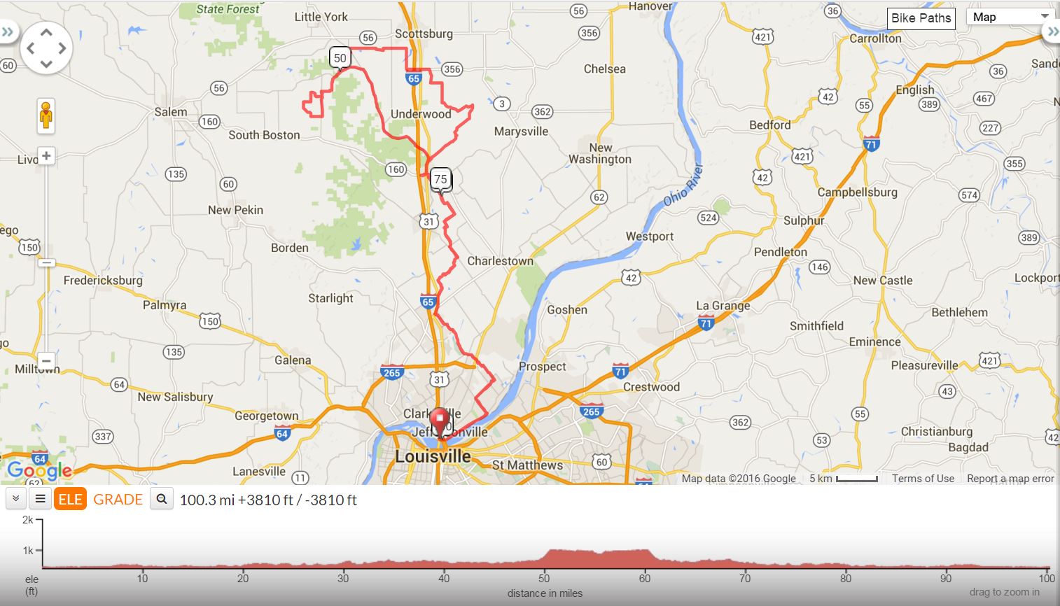
Start/Finish: Parking Lot on Missouri Ave, next to 2nd St Bridge in Jeffersonville, IN (big water tower is next to this lot.)
Festival:
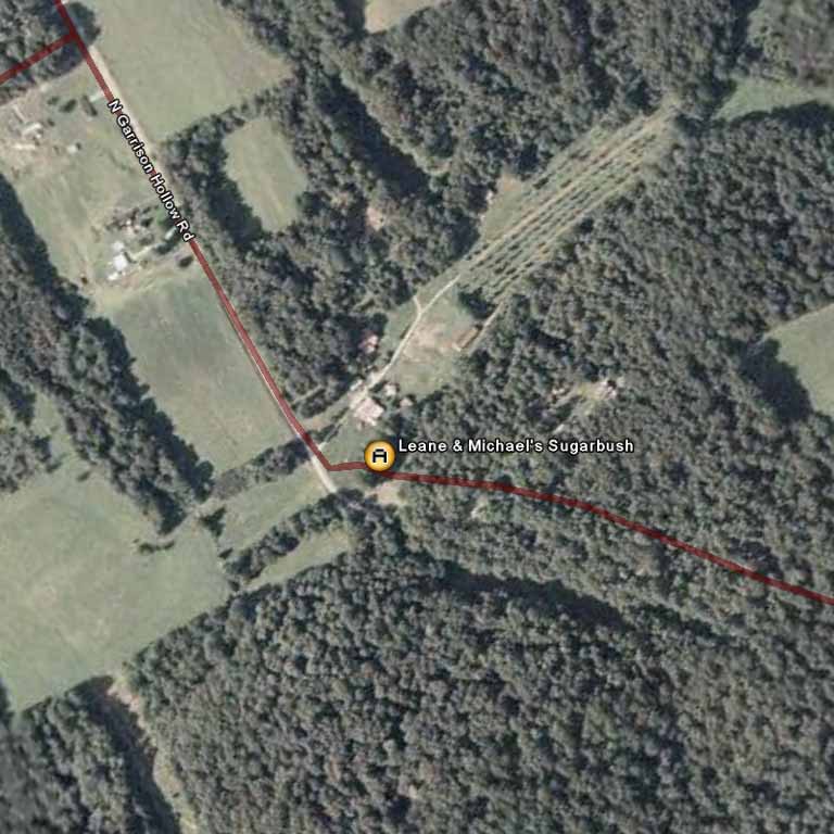
Leane and Michael's Sugarbush
321 N. Garrison Hollow Rd.
Salem, In 47167
(812) 967 - 4491
4150 - Puddle's Maple Syrup Ride |
||
0.0 |
L |
out of parking lot onto Market Street (From Missouri Ave. lot) |
3.9 |
L |
Allison Lane |
5.3 |
R |
Middle Road (SL) (Middle turns to New Middle Rd.) |
7.1 |
L |
New Middle Court (SS) |
7.2 |
S |
Sellersburg-Utica Road (SS) |
8.7 |
L |
New Chapel (SS) |
8.7 |
R |
S-Utica Road (SS) |
9.1 |
X |
US 62 (SS) |
10.0 |
R |
Sellersburg Utica (Becomes Utica in Sellersburg) |
13.9 |
R |
31 N @ Light |
15.2 |
R |
Webster (no sign) |
Caution – Railroad Tracks |
||
16.9 |
R |
Brick Church (SS) |
19.0 |
L |
Stoney Point (SS) |
20.0 |
R |
Fox (Easy to Miss) |
20.3 |
L |
Trelor |
21.6 |
R |
Hansberry (SS) |
23.6 |
S |
Murphy (becomes Prall Hall Then Pennsyvania) |
L |
Hwy. 160 |
|
X |
Hwy. 31 N |
|
R |
Store Stop – Marathon/Subway |
|
L |
Out of Store on Hwy. 160 |
|
27.0 |
L |
Hwy. 31 N |
28.0 |
R |
Hebron Church Road (TRACKS) |
32.2 |
R |
Beagle Club (SS)-jog right/left |
32.2 |
L |
Saw Mill (Becomes Slate Ford) |
33.9 |
L |
Kinderhood (SS) |
34.4 |
S |
Werewolf |
36.9 |
S |
Double or Nothing (SS) |
37.9 |
L |
Bridgewater |
38.8 |
R |
Underwood Rd. (SS) |
39.8 |
L |
Hwy. 356 (SS) |
40.4 |
X |
Hwy. 31 to Leota Rd. |
41.6 |
R |
S. Lake Road (SS) |
43.5 |
L |
W. Lake Rd. (SS) |
47.8 |
L |
Zion-Becomes Bloomington@SS |
48.2 |
R |
Stagecoach |
49.3 |
R |
Leota (SS) |
52.5 |
B/L |
at top of hill on N. Salem Rd. |
54.2 |
R |
Thomas Lane |
55.0 |
R |
Garrison Hollow (SS) |
56.0 |
R |
into Festival for lunch |
R |
out of festival |
|
57.6 |
R |
New Philidelphia (SS) |
58.6 |
L |
New Salem (SS) Becomes N. Salem/Finley, then Leota |
63.1 |
R |
Bloomington Trail (SS) |
72.0 |
R |
Hwy. 31 S (SS) |
73.3 |
L |
Hwy. 160 East |
73.4 |
R |
Pennsylvania |
73.5 |
L |
into Store (Henryville) |
L |
out of store |
|
74.3 |
S |
Murphy (SS) |
76.6 |
S |
Hansberry (SS) |
78.6 |
L |
Trelor |
80.0 |
R |
Fox (SS) |
80.3 |
L |
Charlestown Memphis (SS) Go straight when turns to Stoney Point |
81.2 |
R |
Brick Church Road |
83.4 |
L |
Weber Road |
85.0 |
L |
Hwy. 31 South (SS) |
86.4 |
L |
Utica Road @ light |
90.2 |
L |
to stay on Utica/Sellersburg Rd. |
91.1 |
S |
Cross Hwy. 62 |
91.5 |
L |
New Chapel (SS) |
91.5 |
R |
Utica/Sellersburg Rd. (SS) |
93.1 |
S |
Middle (SS) |
93.3 |
S |
New Middle Court (SS) |
93.4 |
R |
New Middle St. (SS) |
93.8 |
X |
Port Rd. to Middle Rd. (SS) |
95.3 |
L |
Allison @ light |
96.6 |
R |
Utica Pike (SS) Becomes Market |
100.5 |
R |
Missouri Ave. to parking lot |
|
||
Printer friendly Cue Sheet (pdf format) (Print on front and back of single page for best result.)
Interact with map or Download GPS File