New Version, October 6, 2020
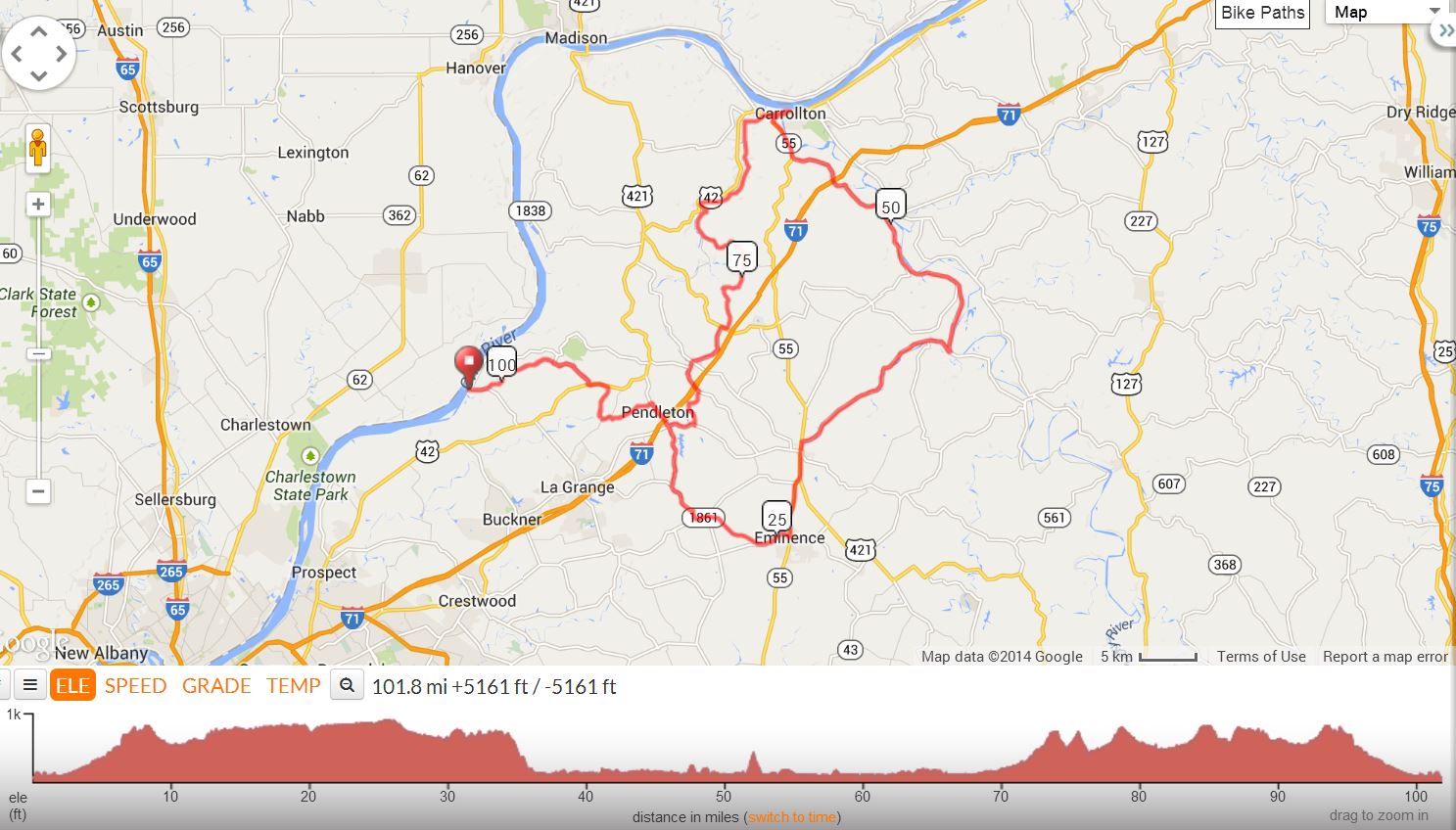
First of all, don't let the name scare you -- The name "Sink or Swim" doesn't mean it's a real killer of a century. It refers to the fact that you may take an optional swim on this ride (in warm weather, of course.) The route starts out of Westport, Kentucky at Westport Baptist Church, 6415 Washington St, Westport, KY 40077
"Sink or Swim" has set attendance records over the years because it's such a
beautiful route along low traffic creek and river roads with lunch at Welch's which features a deck overlooking the Ohio River in Carrollton.
"Gizmo's Relaxed Century" has become known as the "Sink or Swim Century." Since its inception in 2005, the ride has been offered during the Summer months and has been punctuated by an optional dip in the Ohio River both at the mid-point, Carrollton, KY and at the end of the day back in Westport, KY. In 2008, Debbi Hatton won the prize for the most creative swim costume.
Sink or Swim Century, version 4 |
||
Miles |
Turn |
Road |
0.0 |
L |
Westport Baptist Church, Left out of Parking |
0.0 |
L |
Immediate left on 3rd Street |
0.1 |
R |
SR 524 |
0.8 |
L |
Eighteen Mile Creek Rd |
5.0 |
R |
SR 524 |
7.3 |
L |
US 42 |
8.4 |
R |
Tobacco Rd |
10.0 |
L |
Bluegrass Pkwy |
10.3 |
L |
Old Sligo Rd |
10.7 |
R |
L'Espirit Pkwy |
13.1 |
R |
SR 153 |
17.7 |
Bear L |
to stay on SR 153 |
20.0 |
L |
SR 1861(Smithfield Rd ) |
20.7 |
S |
becomes Giltner Rd |
23.8 |
L |
SR 22 at T-intersection, no sign |
25.6 |
L |
SR 55 (N Main St) |
25.7 |
Stop |
Marathon or Dairy Queen |
28.8 |
S |
US 421 (SR 55) |
30.7 |
R |
SR 202 (Drennon Rd) |
40.9 |
L |
SR 389 to keep Kentucky River on right. (Sign Missing. Do not cross bridge here!) |
53.1 |
X |
RR Tracks, SR 389 bends left. |
56.8 |
R |
SR 55 |
59.3 |
R |
US 42 Caution: X Bridge, Kentucky River (Shell Store at this corner across street) |
59.7 |
L |
Immediate Left, 2nd St |
59.8 |
R |
Main St, Ohio River is on the left. |
60.1 |
Stop |
Welch's Riverside Restaurant (Eat on enclosed deck in back overlooking Ohio River) |
60.1 |
Turn Around |
|
60.4 |
L |
2nd St |
60.5 |
R |
US 42 |
61.5 |
L |
Carlisle Rd, (not Old Carlisle!), Little Kentucky River will be on the right. |
70.6 |
L |
SR 316 (Carlisle Rd) |
73.4 |
R |
Clark Rd |
73.8 |
R |
Louden Rd |
76.1 |
L |
Carmon Creek Rd |
78.4 |
R |
US 421 |
78.6 |
L |
SR 1606 |
81.7 |
Bear L |
to X RR Tracks and remain on SR 1606 |
83.1 |
R |
Wolfpen Branch Rd (No sign) |
84.1 |
L |
Dawkins Ln |
85.4 |
R |
SR 146 (Lagrange Rd) |
86.9 |
R |
SR 153 Stop, Valero at Corner |
88.3 |
L |
L'Espirit Parkway |
90.7 |
L |
Old Sligo Road |
91.1 |
R |
Bluegrass Parkway |
91.4 |
R |
Tobacco Road |
93.0 |
L |
US 42 |
94.1 |
R |
SR 524 |
96.4 |
L |
18 Mile Creek |
100.5 |
R |
SR 524 |
101.3 |
L |
3rd St |
101.4 |
R |
Washington St, Immediate rt into Church Parking |
KEY: |
L = Left, R = Right, S = Straight, X = Cross, Red = Caution or Stop, Green =sight worth seeing, Blue = Body of Water |
|
Printer friendly Cue Sheet (pdf format) (Print on front and back of single page for best result.)
Interact with map or Download GPS File