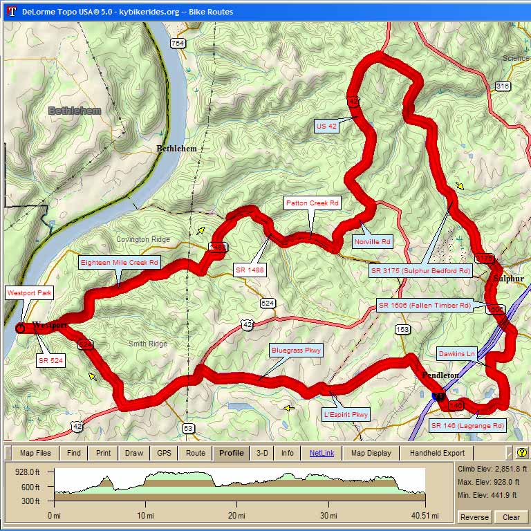
| 3015 – Wings 40 Westport, Bedford, Sulphur, Pendleton 40.7 mi, Cumulative Climb: 2585 ft, avg: 63 ft/mile Dr. Larry Preble, Cell: (502) 724-8477 Home: (502) 509-2362 |
||
| Miles | Turn | Road |
| 0.0 | Start | Westport Park at Ohio River |
| 0.0 | S | Main St out of park |
| 1.0 | L | Eighteen Mile Creek Rd |
| 5.1 | L | SR 524 |
| 5.6 | R | SR 1488 (Covington Ridge Cutoff) |
| 6.1 | Caution: Steep Downhill | |
| 6.9 | R | SR 1488 |
| 8.5 | L | Patton Creek Rd (No Sign) |
| 9.9 | L | Norville Rd |
| 11.5 | L | US 42 |
| 15.8 | R | SR 3175 |
| 22.4 | R | SR 157 |
| 23.0 | L | SR 1606 X RR Tracks |
| 24.3 | R | Wolfpen Branch Rd |
| 25.3 | L | Dawkins Ln |
| 26.5 | R | SR 146 |
| 28.0 | R | SR 153 (Store Stop) |
| 29.4 | L | L'Espirit Pkwy |
| 31.8 | L | Old Sligo Rd |
| 32.2 | R | Bluegrass Pkwy |
| 34.9 | L | US 42 |
| 37.1 | R | SR 524 |
| 40.5 | S | Main St |
| 40.7 | L | Westport Park at Ohio River |
| KEY: | L = Left, R = Right, S = Straight, X = Cross, Red = Caution or Stop, Green =sight worth seeing, Blue = Body of Water | |
Interact with Map or to Download GPS Route