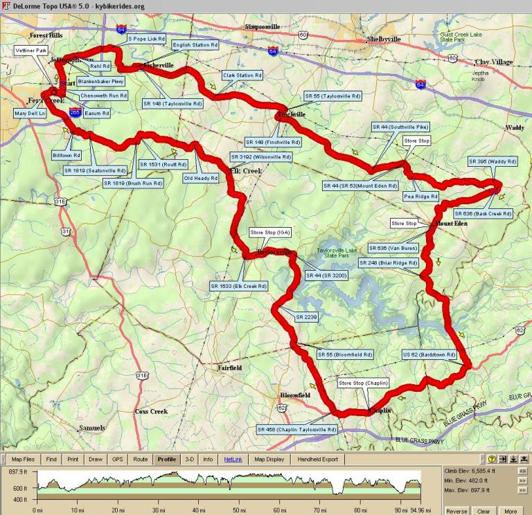
| 2903 - Chaplin Century | ||
|---|---|---|
| 0.0 | Out the back of the park | |
| 0.7 | L | Easum Road |
| 1.0 | L | Chenoweth Run |
| 2.4 | X | Taylorsville Road |
| 3.2 | S | onto Blakenbaker Pkwy |
| 3.9 | R | Rehl Road |
| 6.1 | R | bear right to stay on S. Pope Lick |
| 7.7 | X | Taylorsville Road - BUSY!!! |
| 9.1 | R | KY-148 [Taylorsville Rd] |
| 14.7 | L | Clark Station/Finchville Rd. @ Y |
| 19.1 | R | KY-55 [Taylorsville Rd] |
| 19.7 | L | KY-148 [Finchville Rd] |
| 26.3 | L | KY-44 [Southville Pike] |
| 28.3 | R | KY-53 [Mount Eden Rd] in Southville - store stop |
| 29.4 | L | Pea Ridge Road |
| 34.7 | R | KY-395 [Waddy Rd] |
| 35.1 | R | KY-636 [Back Creek Road] |
| 40.6 | X | KY-44 in Mount Eden |
| 40.7 | S | to stay on KY-636 [Van Buren] - store stop |
| 44.4 | L | KY-248 [Briar Ridge Rd] |
| 50.9 | R | US-62 [Bardstown Rd] |
| 58.0 | store stop in Chaplin | |
| 60.5 | R | KY-458 [Chaplin Taylorsville Rd] |
| 65.5 | R | KY-55 [Bloomfield Rd] |
| 68.4 | R | KY-2239 - pass over the dam |
| 72.1 | L | KY-44 |
| 74.4 | L | KY 44/55 - store stop (IGA) |
| 75.0 | R | KY 44/55 - thru downtown Taylorsville |
| 75.1 | S | KY 44 at light |
| 76.7 | R | KY-1633 [Elk Creek Rd] |
| 79.5 | L | to stay on KY-1633 [Elk Creek Rd] |
| 81.6 | L | KY-3192 [Wilsonville Rd] |
| 84.4 | L | Old Heady Road |
| 88.1 | L | KY-1531 [Routt Rd] |
| 88.6 | R | KY-1819 [Bush Run Rd] |
| 91.4 | S | becomes Seatonville Rd |
| 93.2 | R | Billtown Road (at the top of the hill) |
| 95.9 | R | Mary Dell Lane |
| 96.9 | to parking lot | |