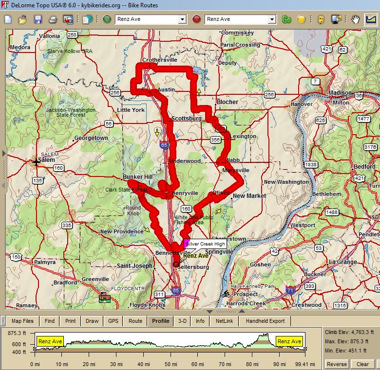
2601 - Silver Creek Century--"Virgin Century"(100) 101 miles, 4763 ft climbing, 47 ft per mile |
||
Mile |
Turn | Street |
0.0 |
L |
Hwy 31 |
0.6 |
R |
Weber Rd (caution! Gravel from cement plant) |
2.2 |
R |
Brick Church Rd |
4.5 |
L |
Stoney Point Rd |
5.4 |
R |
Fox (no sign, 2 nd , right) |
6.4 |
L |
To stay on Fox |
8.3 |
S |
Cross Hwy 160 |
9.4 |
L |
Harry Hughes |
10.6 |
R |
Seattick |
12.6 |
R |
Leon Prall (no sign, at stop sign a& fire station) |
12.9 |
L |
Hwy 3 |
13.7 |
R |
Mill (no sign, across from Citgo) (Store) |
14.6 |
L |
Gum Corner (no sign, at painted tree) |
16.4 |
S |
Cross new market (becomes Naab-N. Wash ) |
19.0 |
L |
Onto Naab – N. Wash |
22.5 |
L |
SR 362 |
23.4 |
R |
SR 203 |
27.2 |
R |
SR 356 ( Main St .) |
|
|
Turn Left on 356 for store stop |
27.5 |
L |
SR 203 |
31.1 |
L |
56 / 203 / 3 |
31.9 |
R |
Napper |
33.5 |
L |
Blocher |
35.7 |
R |
SR 203 |
37.8 |
S |
Cross 256 (Store on Corner) |
40.4 |
L |
Harrod |
41.2 |
R |
Whitsitt |
42.3 |
L |
Crothersville Rd |
49.3 |
R |
31 |
49.4 |
L |
E. Main (quick-ish left) |
49.8 |
L |
Bethany (1025E) at stop sign |
51.9 |
R |
800S |
52.7 |
L |
950E at stop sign |
54.3 |
L |
SR 256 (at T – no sign) |
56.5 |
R |
Dowling (just before I65 interchange) |
56.5 |
L |
Boatman (quick left) |
60.8 |
L |
56 into Scottsburg CAUTION - BUSY ROAD |
|
X |
Cross I65 and 31 |
|
|
Subway on Right before town square |
63.3 |
R |
After courthouse & RR tracks, into town square |
|
R |
To stay in town square |
63.5 |
L |
S. main |
66.2 |
S |
Cross SR356 onto Underwood |
68.3 |
S |
Cross Radio Tower |
69.4 |
S |
Cross County Line Rd |
70.5 |
R |
Beagle Club Rd |
70.5 |
L |
Immediate L on Old Slate Rd |
72.7 |
R |
Hebron Church Rd |
73.3 |
L |
Hwy 31 |
73.8 |
R |
Into Clark Forest |
74.7 |
L |
At Y – White Oak Nature Preserve Sign |
74.8 |
L |
At T – onto 1-way loop |
76.2 |
R |
At T to continue on loop |
78.1 |
R |
Hwy 31 (leaving forest) |
79.0 |
R |
Hwy 160 (stores on right & left) |
85.0 |
L |
Pixlie Knob (caution, downhill!) |
89.8 |
L |
To stay on Pixlie Knob |
90.8 |
R |
Bartle Knob |
91.4 |
L |
Beyl (marked with –O, with CF enclosed in the circle) |
93.2 |
L |
To stay on Beyl, at T |
94.3 |
R |
Crone (at T, no sign) |
94.7 |
L |
Columbus Mann |
95.5 |
S |
Cross Ebenezer Church |
97.5 |
L |
Bud Prather / Perry Crossing |
98.0 |
S |
Cross Hwy 31 |
99.2 |
R |
Weber Rd |
100.9 |
L |
Hwy 31 |
101.5 |
R |
Into school |
Interact with Map or to Download GPS Course