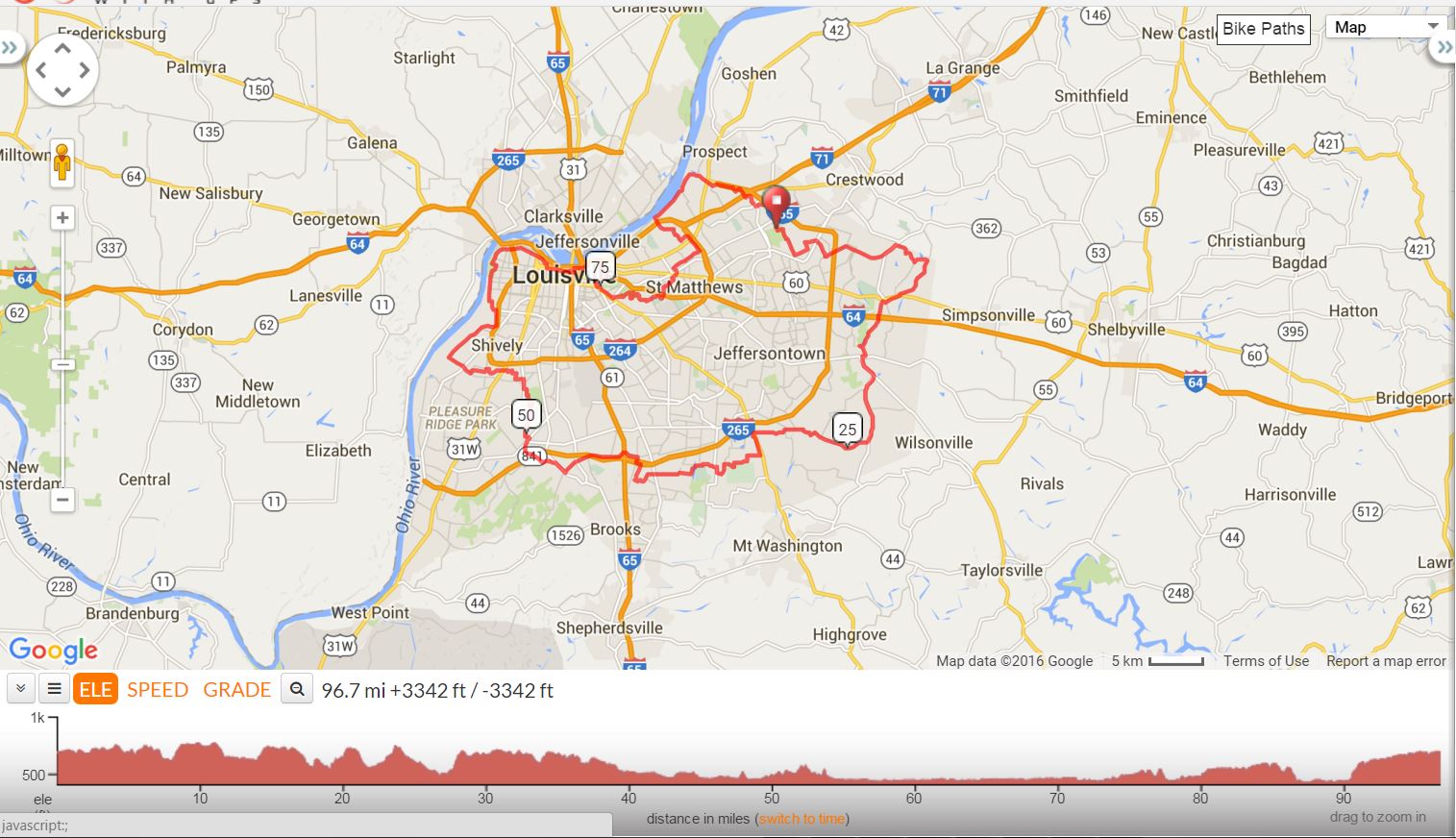
Urbane Century |
||
Mile |
Turn |
Street |
0.0 |
R |
Freys Hill Rd |
0.9 |
L |
Evergreen / Lakeland |
1.9 |
L |
Osage |
3.1 |
R |
Lucas |
3.8 |
X |
Old LaGrange to Stanley Gault |
4.7 |
L |
Old Henry Rd. |
6.0 |
R |
Bush Farm |
6.4 |
S |
Turns into Aiken Rd. |
9.0 |
R |
Flat Rock Rd. |
10.7 |
L |
Long Run Park Rd. |
10.9 |
R |
Long Run Park Rd (before playground) |
11.4 |
R |
Long Run Rd. @ stop |
14.0 |
R |
Shelbyville Rd. US60 |
14.5 |
L |
Eastwood Cut Off |
15.0 |
L |
Gilliland Rd. |
16.2 |
S |
Turns into Echo Trail |
17.9 |
L |
English Station @ stop |
18.5 |
R |
Taylorsville Rd. |
18.7 |
L |
Taylorsville Lake Rd. @light US155 |
20 |
R |
Routt Rd. US1531 |
23.5 |
R |
Brush Run (Fern Creek Fire Dept) US1819 turns into Seatonville Rd. |
28.5 |
L |
Brentlinger Ln (in the curve-easy to miss) |
30.4 |
L |
Bardstown Rd. |
30.5 |
Stop |
Thornton’s Store Stop |
30.5 |
R |
Bardstown Rd. |
30.8 |
R |
Old Bardstown/Hillock |
31.8 |
R |
Fairmount Rd. |
32.5 |
L |
Fairmount/Gentry Ln |
32.9 |
BR |
Fairmount Rd. |
34.3 |
L |
Cedar Creek Rd @ stop |
35.2 |
R |
Cooper Chapel 864@ stop |
35.6 |
L |
Cooper Chapel @ 3way stop |
36.1 |
L |
Cooper Chapel Follow McNealy lake sign |
36.7 |
L |
McNeely Park |
37.3 |
R |
Price Ln @ stop |
38 |
L |
Cooper Chapel |
39.3 |
X |
Preston onto Commerce Crossing |
40.1 |
R |
Carbin Lane |
Go around gate |
||
40.6 |
R |
Caven @ stop |
41.5 |
L |
Maynard @ stop |
41.7 |
R |
Blue Lick @ stop |
42.2 |
L |
South Park @ light |
44.9 |
X |
RR tracks – rd becomes Fairdale |
45.5 |
X |
National Turnpike @ light |
46.5 |
Lunch |
Dairy Queen @ flashing light or Across Street |
46.5 |
R |
Manslick |
46.9 |
L |
West Manslick US 2055 |
47.7 |
BR |
W. Manslick @ stop |
49.1 |
R |
3rd St. Rd. |
49.5 |
L |
Wisertown |
49.8 |
R |
Manslick |
51.3 |
X |
Palatka @ light to Sanders Gate |
51.6 |
L |
Randill |
52.2 |
L |
Iroquois Pkwy |
52.4 |
R |
Morocco |
52.7 |
L |
Tunsian |
52.8 |
R |
Manslick |
53.3 |
L |
Knight |
53.7 |
R |
Estate |
54 |
L |
Anna |
54.2 |
R |
Yolanda |
54.3 |
L |
Sadie |
54.5 |
X |
RR Tracks |
54.5 |
R |
San Hose |
54.7 |
L |
Sanders |
54.8 |
R then |
Cross Dixie @ Light to Heaton |
55.4 |
R |
Kendall |
55.6 |
R |
Spen Lea |
55.8 |
L |
Luckert |
56 |
L |
Martin |
56.9 |
L |
Dover |
57.1 |
R |
Rockford Ln |
57.6 |
X |
Cane Run to Lees Ln |
58.5 |
R |
Camp Ground (KY2051) |
61.7 |
L |
Levee Trail |
62.3 |
X |
Bells Lane |
62.5 |
L |
Algonquin Pkwy |
64.5 |
X |
Broadway into Shawnee Park |
64.9 |
R |
Out of Park |
65.0 |
L |
Southwestern Pkwy |
65.3 |
L |
Southwestern Pkwy |
65.5 |
R |
Southwestern Pkwy |
Turns into Northwestern Pkwy |
||
66.4 |
R |
Bank St |
69.0 |
R |
16th St. |
69.2 |
L |
Market St. |
70.6 |
L |
Brook |
70.9 |
R |
Witherspoon |
71.7 |
R |
River Rd. |
72.1 |
Stop |
Stop Light Liquors on Right or Yellow lot with Bathrooms & Water from Fountain on Left |
72.4 |
R |
Frankfort Ave |
72.8 |
R |
Story |
73.0 |
L |
Spring |
73.5 |
R |
Payne (Optonal Store Stop, no restroom) |
74.2 |
L |
Baxter |
74.4 |
L |
Cherokee Rd. |
75.4 |
BR |
Around round about |
75.4 |
R |
Cherokee Pkwy |
75.8 |
R |
Cherokee Rd. to round about(Daniel Boone Statue) |
76 |
S |
Into Scenic Loop |
76.4 |
R |
Cherokee Park Rd. |
Stay on Scenic Loop (Hogan’s Ftn) |
||
76.7 |
L |
Cherokee Park Rd. |
77.6 |
R |
Cherokee Park Rd. @ stop |
77.8 |
L |
Beargrass |
78 |
L |
Beargrass |
78.5 |
L |
Seneca park Rd.@stop |
78.8 |
S |
3 way stop |
78.9 |
R |
Seneca Park Rd. |
79.6 |
L |
Old Cannons |
79.8 |
L |
Huntington |
79.9 |
R |
Alden |
80 |
R |
Chamberry |
80.2 |
S |
Chamberry |
80.3 |
X |
Cannons Ln to Nanz |
80.8 |
L |
Wallace |
81 |
R |
Willis |
81.3 |
X |
Shelbyville Rd. |
81.4 |
R |
Westport |
81.4 |
L |
St. Matthews Ave. |
81.6 |
R |
Massie |
82.3 |
R |
Hubbards |
82.3 |
L |
Rudy |
84 |
X |
Brownsboro Rd. |
84.2 |
L |
Appache |
84.6 |
R |
Blankenbaker |
86.8 |
R |
River Rd. |
90.1 |
R |
Wolf Pen @ stop |
90.8 |
X |
US42 |
91.1 |
L |
Wolf Pen Branch |
91.4 |
R |
Springdale |
94 |
X |
Brownsboro Rd. |
94.2 |
L |
Springhurst |
95.8 |
X |
Westport Rd. |
96.3 |
R |
E.P. Tom Sawyer Park |