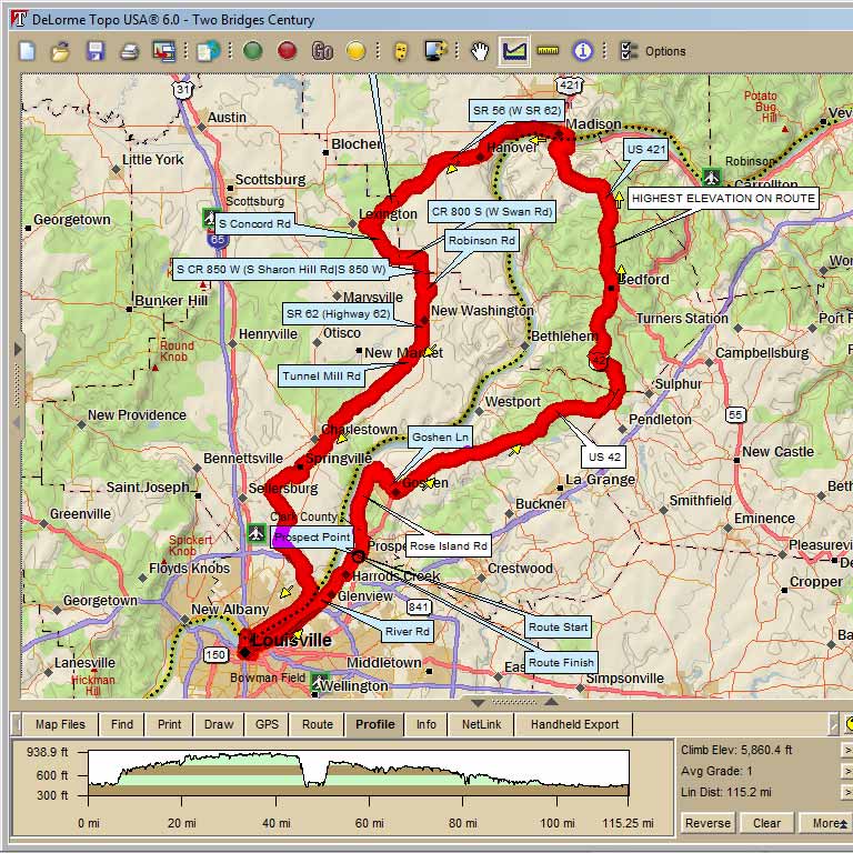
Challenging 116 mile century ride that leaves from Prospect Point Shopping Center in Prospect, KY, proceeds northeast to cross the Ohio River into Indiana at Madison, and then goes dowonstream to cross the river again in Louisville before returning to Prospect.
This recent note from an interested rider informed us of a store stop closing and offers a suggestion for an alternate:
"Hi,
I was looking ride 2305. I live in Charlestown. There is a store list at mile 85.1. That store closed a couple of years ago.
But, when you are on Main St. If you turn L on Main Cross St. There is a BP in 3 blocks.
Donna"
Two Bridges Century |
|||
AT |
TURN |
ROAD |
GO |
0.2 |
L |
US 42 |
0.8 |
1.0 |
L |
ROSE ISLAND ROAD |
5.6 |
6.6 |
R |
UP GOSHEN LANE |
2.7 |
9.3 |
L |
US 42 |
16.4 |
25.7 |
R |
MARATHON STORE STOP (SLIGO) |
0 |
34.7 |
L |
US 421 @ FLASHING YELLOW LIGHTS |
12.8 |
47.5 |
L |
E. 1ST AVENUE |
0.1 |
47.6 |
R |
BALTIMORE ST |
0.2 |
47.8 |
L |
MAIN ST / SR 56 (SUBWAY ON LEFT) |
9.5 |
57.3 |
L |
SR 62 |
0.3 |
57.6 |
R |
SR 356 |
6.3 |
63.9 |
L |
S. CONCORD ROAD |
2.3 |
66.2 |
L |
HARDY MILL ROAD (OVER CREEK) |
0.7 |
66.9 |
L |
SWAN ROAD |
1.8 |
68.7 |
R |
COUNTY ROAD 850 |
1.0 |
69.7 |
X |
SR 362 (ONTO ROBINSON RD) |
1.0 |
70.7 |
R |
CONTINUE ON ROBINSON RD |
0.5 |
71.2 |
R |
CARROL ROAD |
0.1 |
71.3 |
R |
SR 62 |
3.4 |
74.7 |
R |
TUNNEL MILL ROAD |
9.8 |
84.5 |
L |
MONROE ST |
0.1 |
84.6 |
R |
MAIN ST |
0.4 |
85.0 |
L |
SR 3 |
0.1 |
85.1 |
R |
HIGH STREET (STORE STOP) |
2.6 |
87.7 |
R |
BETHANY ROAD |
0.4 |
88.1 |
L |
HIGH JACKSON ROAD |
1.8 |
89.9 |
L |
SALEM NOBLE ROAD |
2.4 |
92.3 |
R |
CHARLESTOWN PIKE |
1.7 |
94.0 |
L |
UTICA SELLERSBURG ROAD |
0.6 |
94.6 |
X |
SR 62 |
0.4 |
95.0 |
L |
NEW CHAPEL RD |
0.1 |
95.1 |
R |
UTICA SELLERSBURG ROAD |
1.5 |
96.6 |
S |
MIDDLE ROAD |
0.1 |
96.7 |
S |
NEW MIDDLE ROAD |
0.1 |
96.8 |
R |
NEW MIDDLE ROAD |
0.5 |
97.3 |
L |
PORT ROAD |
1.0 |
98.3 |
R |
UTICA PIKE (BECOMES MARKET) |
5.5 |
103.8 |
R |
MISSOURI AVENUE |
0.2 |
104.0 |
X |
CLARK MEMORIAL BRIDGE |
1.2 |
105.2 |
L |
MARKET ST |
0.5 |
105.7 |
L |
JACKSON ST (X MAIN THRU BALL PARK) |
0.3 |
106.0 |
R |
WITHERSPOON ST |
0.5 |
106.5 |
R |
RIVER ROAD |
9.1 |
115.6 |
R |
PARKING LOT |
0.1 |
115.7 |
R |
OPTIONAL DAIRY QUEEN |
|
 Map Images are copyright © 2006 Delorme, TOPO USA ® and are provided pursuant to their End User Licensing Agreement. Visit http://www.delorme.com for more information.