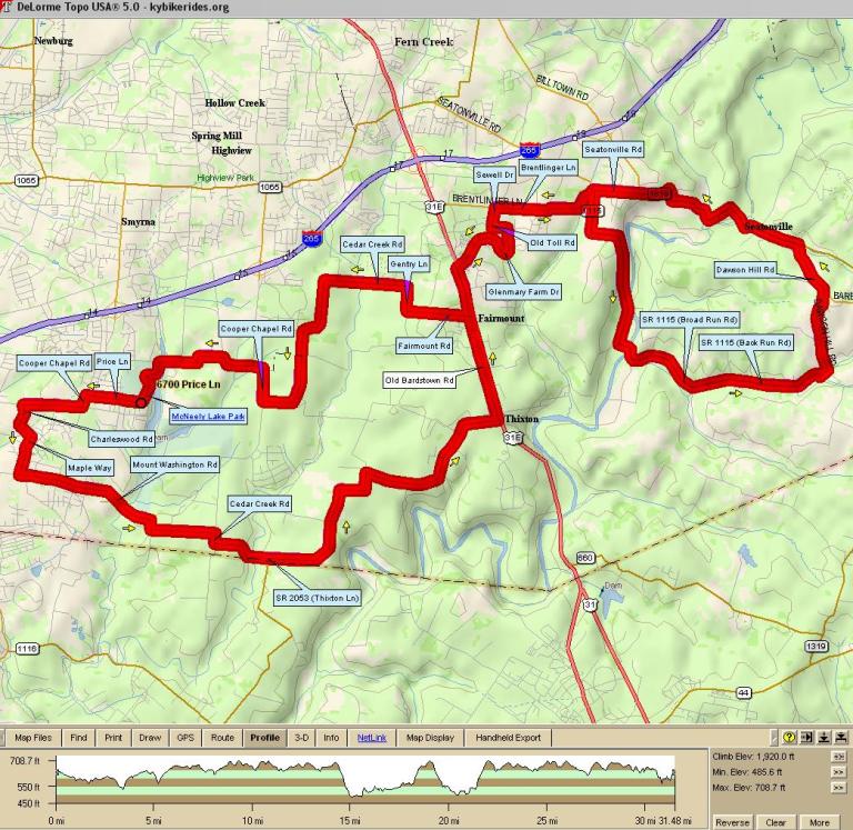
| 2002 - McNeely Lake (31A) | ||
|---|---|---|
| 0.0 | L | Out of Parking Lot onto Price Lane |
| 0.6 | L | Cooper Chapel Rd |
| 1.3 | L | Charleswood |
| 1.7 | R | Maple |
| 2.2 | L | Mt. Washington |
| 4.5 | R | SR 2053 (Cedar Creek Rd) |
| 4.7 | R | SR 2053 (Thixton Rd) |
| 9.0 | L | Old Bardstown |
| 10.8 | R | Providence |
| 10.8 | X | Bardstown Rd onto Glenmary Farm Dr |
| 11.8 | L | Colonel Hancock |
| 12.0 | R | Old Toll |
| 12.1 | L | Sewell |
| 12.2 | R | Brenlinger |
| 13.4 | R | Seatonville Rd |
| 13.5 | R | KY-1115 [Broad Run Rd] (immediate right) |
| 18.0 | L | Dawson Hill Rd |
| 19.6 | L | KY-1819 [Brush Run Rd] |
| 21.7 | S | Seatonville |
| 22.3 | L | Brentlinger Ln |
| 23.5 | L | Sewell Dr |
| 23.6 | R | Old Toll Rd |
| 23.7 | L | Colonel Hancock Dr |
| 23.8 | R | Glenmary Farm Dr |
| 24.9 | X | Bardstown Rd onto Providence |
| 24.9 | L | Old Bardstown Rd |
| 25.5 | R | Fairmount Rd |
| 26.2 | R | Gentry Ln |
| 26.6 | S | Cedar Creek Rd |
| 29.2 | R | Cooper Chapel Rd |
| 30.8 | L | Park Rd (into McNeely Lake Park) |
| 31.4 | X | Price Ln into Wilt Elementary Parking Lot |