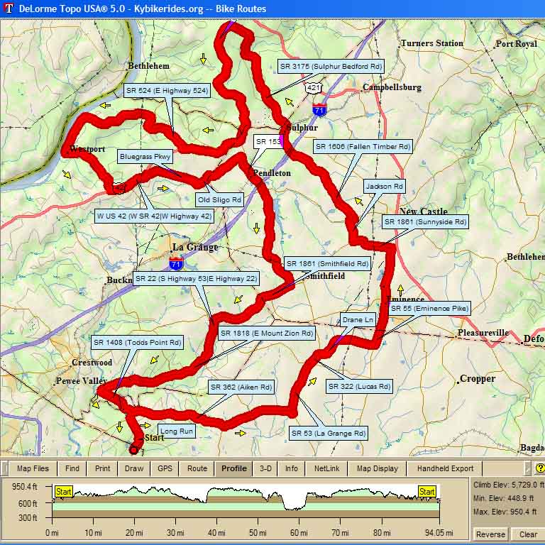
1900 – Long Run Park to Westport Century |
||
| Miles | Turn | Road |
| 0.5 | L | Long Run Rd |
| 2.4 | R | 362 |
| 7.7 | L | 362 |
| 11.3 | L | 53 |
| 13.8 | R | 322 |
| 14.6 | R | Drane Lane |
| 17.8 | L | 55 |
| Store Stop in Eminence | ||
| Continue N on 55 | ||
| 22.9 | L | 1861 |
| 25.0 | R | Jackson |
| 26.1 | R | 146 |
| 26.4 | L | 1606 |
| Store Stop in Sulphur | ||
| 32.8 | L | 3175 |
| 39.5 | L | 42 |
| Store Stop in Sligo | ||
| 50.0 | R | 524 |
| Lunch Stop Westport | ||
| 62.2 | L | 42 |
| 64.3 | R | Bluegrass Pkwy |
| 67.0 | L | Old Sligo |
| 67.5 | R | L'Esprit Pkwy |
| 69.8 | R | 153 |
| 76.7 | R | 1861 |
| 78.0 | S | 22 |
| 81.3 | L | 53 |
| 81.9 | R | 1315 |
| 83.5 | R | 1818 |
| 89.3 | L | 1408 |
| 91.3 | R | 362 |
| 91.6 | L | Long Run Rd |
| 93.4 | R | into Park |
| 94.0 | FINISH | |