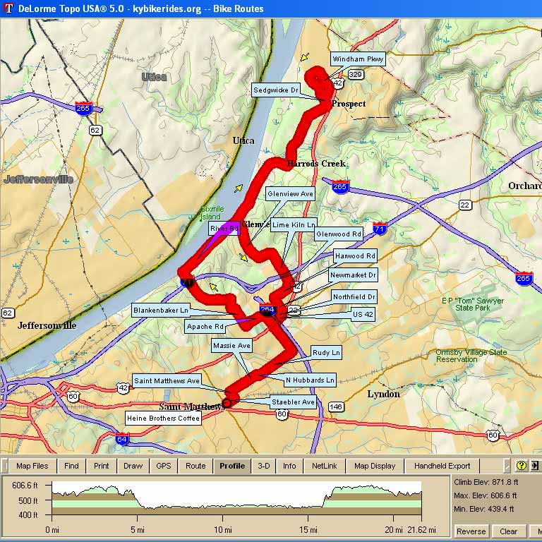
| Heine Brothers “Flood Ride” |
||
| 0 |
L |
Staebler (out of parking lot) |
| 0.2 |
L |
St. Matthews (stop sign) |
| 0.4 |
R |
Massie (stop sign) |
| 1 |
R |
Hubbards (then, immediate |
| 1.1 |
L |
|
| 2.7 |
X |
|
| 2.9 |
L |
Apache |
| 3.4 |
R |
Blankenbaker (stop sign) |
| 5.5 |
R |
River Road (light) |
| 7.1 |
R |
|
| [25 milers (in bold)], continue River Road to Sutherland Subdivision |
||
| 10.5 |
L |
Sedgwick Dr |
| 10.8 |
R |
Windham Pkwy |
| 12.6 |
R |
|
| 12.8 |
R |
River Road |
| 16.0 |
L |
|
| {15-milers subtract 8.9 from mileage below} |
||
| (16.5 bear right; 16.7 bear left) |
||
| 17.0 |
L |
Brittany Wood (near top of hill) |
| 17.3 |
L |
to stay on Brittany Wood |
| 17.4 |
R |
Lime Kiln (stop sign) |
| 17.8 |
( Go over I-71) |
|
| 18.1 |
R |
Glenwood, then immediate |
| 18.15 |
L |
Harwood |
| 18.6 |
L |
|
| 19.0 |
R |
on |
| 19.1 |
R |
|
| Get in lane that goes straight; |
||
| 19.3 |
L |
(from turn lane) on Rudy (light) |
| 20.9 |
R |
Hubbards, then immediate left |
| 21.0 |
L |
Massie |
| 21.6 |
L |
St. Matthews |
| 21.8 |
R |
Staebler |
| 22.0 |
R |
parking lot (across from Heine) Finished! (22.0 minus 8.9 = 13.1) |