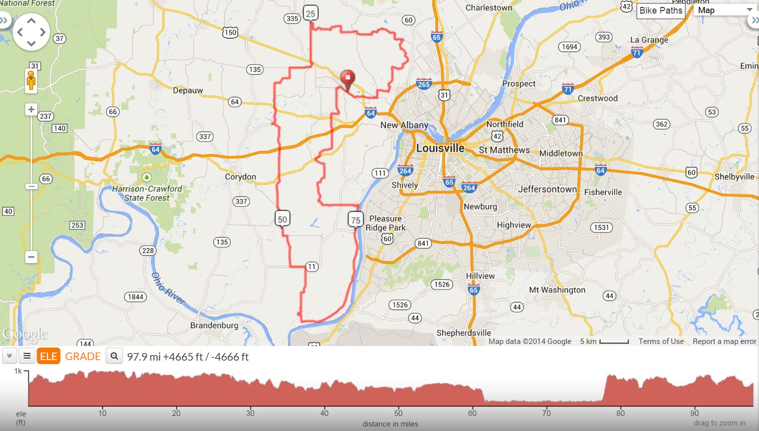
A hilly century ride in the area around Floyd's Knobs, Indiana made even tougher by the addition of a steep, long switchback climb up Doolittle Hill. This ride is a challenge, even for experienced riders but is scenic and worth the effort--Usually on the Louisville Bicycle Club ride schedule about once per year.
Doolittle Hill Century 98 Miles. RC Dick Rauh |
||
0.0 |
R |
Exit Parking lot onto Old Vincennes Rd |
.9 |
L |
Luther (SS) |
1.7 |
X |
SR 150 |
3.0 |
R |
Paoli Pike |
3.2 |
L |
Scottsville Rd @ light |
4.0 |
R |
St. Mary’s Rd. |
4.1 |
BR |
Onto Spickert Knob |
5.4 |
S |
Onto S. Skyline Dr. (SS) |
7.9 |
R |
Moser Knob, up hill |
8.5 |
L |
N. Skyline |
12.9 |
L |
St. Johns Rd |
13.7 |
R |
tso St. Johns (at curve) |
17.1 |
R |
tso St. Johns |
19.0 |
S |
tso St. Johns (SS) |
20.8 |
L |
tso St. Johns (Stumblers) |
21.9 |
L |
Greenville-Borden (SS) |
22.1 |
R |
Temple |
23.1 |
R |
Tom Evans (SS) |
24.1 |
R |
Green (SS) |
24.7 |
L |
tso Green (SS) |
25.0 |
L |
Voyles |
28.8 |
L |
SR 150 |
29.0 |
R |
Georgetown-Greenville Store Stop (L out of store) |
29.4 |
R |
Bradford |
31.6 |
L |
Coen Tush |
32.6 |
R |
Nadorff |
34.4 |
L |
Walk |
35.6 |
S |
@ SS |
36.8 |
L |
SR 64 |
37.1 |
R |
SR 335 (to Crandall) |
38.6 |
L |
Crandall-Lanesville |
39.4 |
R |
Up hill |
40.0 |
turns into Pfrimmer Chapel |
|
47.5 |
L |
Corydon-New Middletown |
48.0 |
L |
Main St |
48.1 |
R |
3rd St. Lunch Stop. (R out of store on 3rd St.) |
50.7 |
L |
tso Elizabeth-New Middltwn |
51.2 |
R |
Pumping Station |
54.3 |
L |
SR 11 |
55.9 |
R |
Old Dam 43 Rd |
59.3 |
S |
@ Sunset Strip |
61.2 |
L |
Old Dam 43 Rd. Curvy downhill |
62.5 |
L |
SR 111 (SS) |
77.6 |
L |
Doolittle Hill!!! |
78.3 |
R |
Lotticks Corner |
79.8 |
X |
SR 11 |
81.7 |
R |
Black Creek |
82.7 |
L |
St. John’s Church Rd |
87.7 |
R |
SR 62 Store Stop: Food Mkt on L |
88.2 |
L |
Tandy |
89.8 |
BL |
Old Salem |
93.0 |
R |
SR 64/Main - quick L coming |
930. |
L |
Henriott |
93.4 |
R |
Frank Ott (SS) |
94.1 |
L |
Alonzo Smith |
96.8 |
R |
John Pectol |
97.1 |
R |
Old Vincennes |
98.1 |
R |
Parking Lot |
SS = stop sigh tso = to stay on BR = bear left X = cross |
||
Printer friendly Cue Sheet (pdf format) (Print on front and back of single page for best result.)
Interact with map or Download GPS File