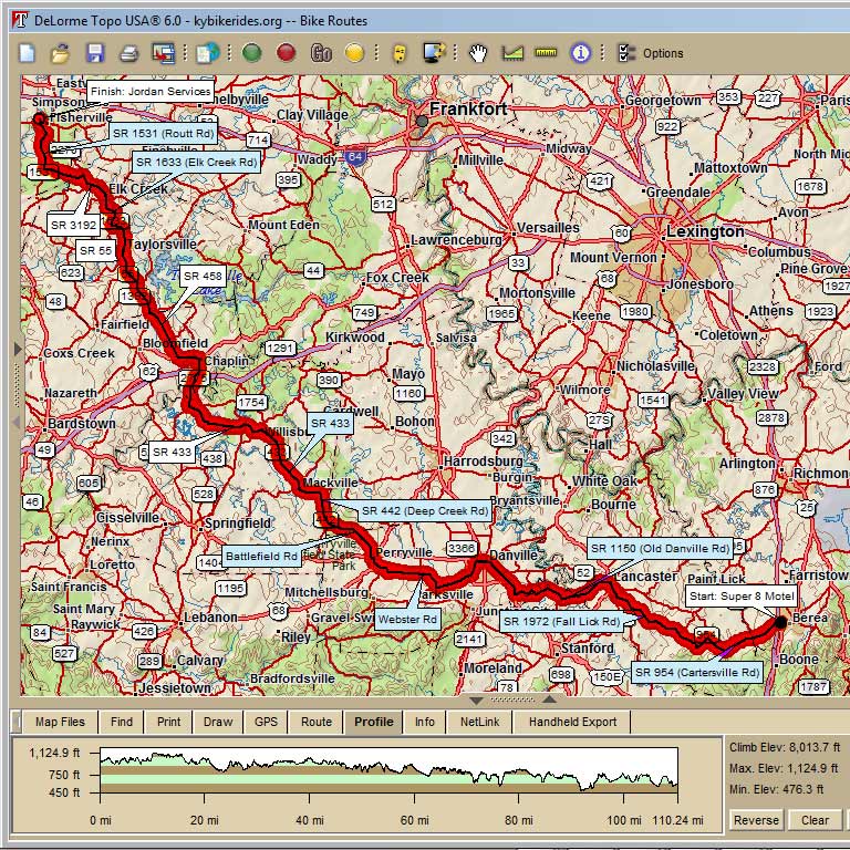
Louisville to Berea and Back
This two day ride is part of TOKYO (Tour of Kentucky Overland,) a creation of Steve Rice. The more extensive ride is not listed here but goes on for 400 miles, touring some scenic back roads through Kentucky. For those with less time to spare, this 212 mile route provides a nice compromise with many shady climbs, great views, and little back roads most people don't know about. Enjoy.
Jordan Services -
to Berea, KY Outbound |
||
0.0 |
R |
English Station |
0.1 |
R |
Hwy 148 |
0.3 |
L |
Hwy 155 |
1.5 |
R |
Routt |
4.7 |
L |
Old Heady |
8.4 |
R |
Hwy 3192 |
11.1 |
R |
Elk Creek |
13.3 |
R |
Elk Creek@ "T" KY1633 |
17.1 |
L |
Hwy 44 |
17.7 |
R |
Hwy 55 (Store if needed) |
24.0 |
L |
Hwy 458 (By OKHT SAG) |
28.9 |
L |
US 62 / Hwy 458 |
30.9 |
R |
Hwy 458 - Chaplin (Store) |
31.2 |
L |
Hwy 1754 |
40.5 |
R |
Hwy 53 |
41.4 |
L |
Hwy 433 – Willisburg Cheeseburger! (Store Stop) |
47.8 |
BL |
Hwy 152 |
49.5 |
BR |
Deep Creek Rd |
52.3 |
BL |
Battlefield Rd (Hwy 120) |
58.2 |
L |
US 150 – Perryville (Store) |
58.4 |
R |
S Bragg |
59.4 |
L |
Webster |
61.1 |
R |
Stay on Webster |
63.2 |
X |
Jog to the left to cross road and stay on Webster |
65.6 |
L |
Hwy 34 |
70.2 |
R |
W Main - US 150 – Danville (Stores) |
71.4 |
R |
US 150 |
74.0 |
L |
US 150 (Busy) |
75.1 |
L |
Chrisman Ln |
76.8 |
R |
Chrisman Spur |
78.5 |
R |
Hwy 590 |
80.2 |
L |
Hwy 1150 |
81.3 |
L->BR |
Cross bridge and bear right to stay on Old Danville Rd |
84.2 |
R |
Hwy 52 (Store Stop) |
85.0 |
R |
US 27 |
85.2 |
L |
Crab Orchard |
86.5 |
L |
Hwy 17972 Fall Lick |
90.4 |
L |
Hwy 1972 Gaffney |
92.8 |
R |
Hwy 1647 |
93.3 |
R |
Good Hope Church |
93.5 |
R |
Old Richmond |
93.7 |
L |
Brock |
95.7 |
L |
Starnes |
97.0 |
R |
Hwy 954 |
98.9 |
L |
Hwy 954 |
102.0 |
R |
Hwy 21 |
105.0 |
L |
Prince Royal |
Berea, KY to
Jordan Services - Inbound |
||
0 |
R |
Hwy 21 |
0.1 |
L |
Hwy 954 |
2.9 |
L |
Hwy 954 |
5.8 |
R |
Hwy 954 |
7.7 |
L |
Harmons Lick Rd |
8.6 |
S |
Starnes |
9 |
R |
Brock Rd |
11 |
R |
Old Richmond Rd |
11.2 |
L |
Good Hope Church Rd |
11.4 |
L |
Hwy 1647 |
11.9 |
L |
Hwy 1972 |
14.3 |
R |
Fall Lick Rd |
18.2 |
R |
Crab Orchard St |
19.5 |
R |
Hwy 27 (Lancaster) |
19.7 |
L |
Hwy 52 |
20.5 |
L |
Old Danville Rd |
23.4 |
L |
Hwy 1150 |
24.5 |
Hwy 590 (R or S - can't tell from map) |
|
26.2 |
L |
Fox Spoonamore - becomes Chrisman |
27.9 |
L |
Chrisman Rd |
29.6 |
R |
Hwy 150 |
30.7 |
R |
Hwy 150 (leave bypass) |
33.3 |
L |
E Main (Danville) Coffee Shop (Store Stop) |
34.5 |
L |
Hwy 34 (Lebanon Rd) |
39 |
R |
Irvin Rd |
41.4 |
L |
Webster Rd |
45.2 |
R |
Mitchellsburg Rd |
46.3 |
L |
Hwy 150 (W 2nd St Perryville) |
46.4 |
R |
N Buell St |
46.5 |
R |
Jackson St |
46.8 |
S |
Becomes Battlefield Rd (Hwy 1920) |
52.5 |
BR |
Becomes Deep Creek Rd (Hwy 422) |
55.1 |
BL |
Harrodsburg Rd (Hwy 152) |
55.8 |
S |
Becomes Mackville Rd |
56.9 |
BR |
Becomes Hwy 433 |
63.2 |
Willisburg Cheeseburger!!!! (Store Stop) |
|
63.2 |
Continue on Hwy 433 |
|
63.9 |
R |
To Stay on Hwy 433 |
71.8 |
R |
Hwy 458 |
76.4 |
L |
Hwy 62 (Chaplin) |
78.3 |
R |
Hwy 458 |
83.3 |
R |
Hwy 55 |
89.7 |
R |
Hwy 44 |
89.8 |
L |
Stay on Hwy 44 |
90 |
Dairy Queen!!! (Store Stop) |
|
91.8 |
L |
Yoder Rd |
92.8 |
R |
1633 @ T |
94 |
L |
1633 (Elk Creek) |
96.1 |
L |
Hwy 3192 |
98.8 |
L |
Old Heady |
99.3 |
R |
over bridge (still Old Heady) |
102.5 |
R |
Routt Rd |
105.7 |
L |
Taylorsville Lake Rd |
106.9 |
R |
Taylorsville Rd |
107.1 |
L |
S English Station |
107.2 |
L |
Jordan Services |
Map Images are copyright © 2004 Delorme, TOPO USA ® and are provided pursuant to their End User Licensing Agreement. Visit http://www.delorme.com for more information.