TOUR OF TALL SHELBY (TOTS) |
||
Start Floyd's Fork Park |
||
0.0 |
L |
S Pope Lick Rd |
0.4 |
R |
Old Taylorsville Rd |
1.9 |
L |
Fisherville Rd at Post Office |
2.0 |
R |
Hwy 148 |
15.0 |
R |
Figgs Store Rd |
17.4 |
L |
Cross Creek and up the hill |
19.2 |
BL |
Little Mt Church Rd |
19.5 |
BR |
Little Mt Church Rd - past cemetary |
21.4 |
X |
Hwy 44 |
21.4 |
S |
Ky-1795 |
23.2 |
L |
Little Elk (Lots of gravel) |
24.3 |
L |
Spaulding Rd (no sign - go up the hill) |
27.7 |
R |
Hwy 44 |
30.0 |
R |
Hwy 636 |
30.0 |
Stop |
Store Stop Mt Eden |
30.0 |
L |
Back on 636 across Hwy 44 |
35.4 |
R |
Hwy 395 |
36.9 |
L |
Hwy 1472 |
37.2 |
R |
Benson Rd |
40.6 |
L |
Hwy 512 (stay on 512 until Alton Station) |
45.4 |
Stop |
Store stop Alton Station |
45.4 |
L |
Hwy 151 |
46.0 |
R |
McCormick Ln |
47.1 |
R |
Turn right onto Hammond Rd |
48.0 |
L |
Hwy 326 |
49.8 |
L |
Lanes Mill Rd |
51.4 |
L |
Wash Rd |
52.9 |
L |
Mills Ln |
54.0 |
R |
US 127 N |
54.2 |
R |
Lawrenceburg Rd (Parallels 127) |
55.4 |
L |
Evergreen Rd - Hwy1665 |
59.1 |
R |
Bridgeport Rd |
59.2 |
L |
Bridgeport-Benson Rd - Hwy 1665 |
63.4 |
L |
Hwy 1005 Devils Hollow Rd |
66.1 |
L |
Hwy 1005 |
66.7 |
R |
Hwy 1005 |
70.0 |
L |
Hwy 12 |
70.0 |
R |
Hwy 12 |
71.0 |
Stop |
Bagdad |
71.1 |
R |
Hwy 12 |
75.3 |
L |
Stapleton Rd |
77.1 |
R |
Hwy 1005 Vigo Rd |
78.9 |
L |
Cranborne Grange |
80.2 |
R |
Benson Pike |
81.9 |
R |
Benson Pike |
82.0 |
L |
Hwy55 (Shelbyville) |
82.1 |
R |
US 60 |
84.2 |
L |
Mack Walters Rd (becomes Zaring Mill) |
90.9 |
R |
Hwy 148 |
104.1 |
L |
Fisherville Rd |
104.2 |
R |
OldTaylorsville |
105.7 |
L |
S Pope Lick Rd |
106.1 |
Finish |
Floyd's Fork Park |
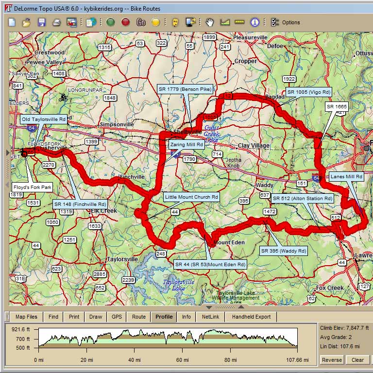
Map Images are copyright © 2004 Delorme, TOPO USA ® and are provided pursuant to their End User Licensing Agreement. Visit http://www.delorme.com for more information.