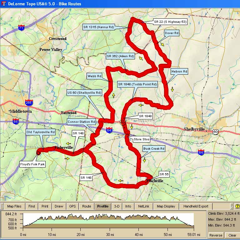
| 1312 - Floyds Fork Park 58 58.4 mi, Cumulative Climb: 3524 ft, avg: 60 ft/mile, Start Al. 545' Start: Floyd's Fork Park, Louisville, KY RC: Ed Tonini |
||
| Miles | Turn | Road |
| 0.0 | L | Leave Park (S. Pope Lick Road) |
| 0.3 | R | Old Taylorsville Rd |
| 1.8 | L | Fisherville Rd. (by Postoffice) |
| 1.9 | R | East 148 (Taylorsville Rd) |
| 4.6 | L | Conners Sta Rd (not Clark Station) |
| 8.2 | R | Colt Run (no street sign at "T") |
| 8.7 | R | Hwy 60 (Caution Busy Road) |
| 9.2 | L | Webb Rd |
| 14.1 | R | Aiken Rd (Hwy 362) |
| 17.2 | L | Aiken Rd (Hwy 362) at Store |
| 18.7 | L | Hanna Road (Hwy 1315) |
| 24.2 | R | Highway 53 (Caution Busy) |
| 26.3 | R | Dover Road |
| 29.7 | R | Aiken Rd. (Hwy 362) |
| 30.4 | L | Hebron Rd |
| 32.7 | S | At Anderson Road |
| 34.0 | R | Harrington (not Harrington Mill straight) |
| 34.3 | R | Antioch Rd (by the church) |
| 37.8 | L | Hwy 1848 (Todd's Point Rd) |
| 40.3 | L | Hwy 60 (Stores in Simpsonville) |
| 40.4 | R | Old Veechdale Rd |
| 40.7 | L | Rolling Ridge (to get over to 1848) |
| 41.7 | R | Hwy 1848 |
| 42.0 | S | Buck Creek at (B.P. store) |
| 43.2 | L | Follow BuckCreek at Taylor Wood |
| 45.9 | L | Hwy 1848 toward Finchville |
| 47.0 | R | Hwy 55 into Finchville |
| 47.7 | R | Hwy 148 back toward Fisherville |
| 56.5 | L | Fisherville Rd. (by Postoffice) |
| 56.6 | R | Old Taylorsville Rd |
| 58.1 | L | S. Pope Lick Road |
| 58.4 | R | into Floyds Fork Park |
| (R) right (L) left (X) cross (S) straight | ||
Map Images are copyright © 2004 Delorme, TOPO USA ® and are provided pursuant to their End User Licensing Agreement. Visit http://www.delorme.com for more information.